Tilhar geodata
Tilhar (Uttar Pradesh) is a populated place; located in India in Asia/Kolkata (GMT+5.5) time zone. With population of 57,043 people, there are 777 cities with bigger population in this country. Compared to other cities in India, 84.3% of cities are located further ↓South; 66.1% of cities are located further ←West and 57.4% of cities have higher elevation than Tilhar. Note1


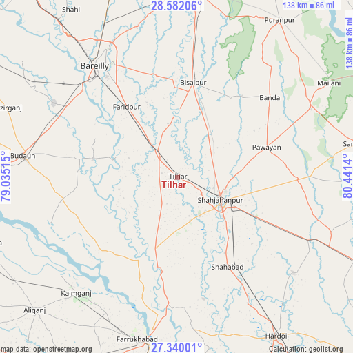
Tilhar GPS coordinates[2]
27° 57' 46.152" North, 79° 44' 17.772" East
| Map corner | latitude | longitude |
|---|---|---|
| Upper-left | 28.58206°, | 79.03515° |
| Center: | 27.96282°, | 79.73827° |
| Lower-right: | 27.34001°, | 80.4414° |
| Map W x H: | 138.1×138.1 km | = 85.8×85.8mi |
| max Lat: | 34.9274° ⇑15.7% North |
| Tilhar: | 27.96282° |
| min Lat: | ⇓84.3% South 8.09008° |
| min Long | Tilhar | max Long |
| 68.82655° | 79.73827° | 96.81° |
| W 66.1%⇐ | ⇒33.9% E |
Elevation
Elevation of Tilhar is 161 m = 528 ft, and this is 134.6 m = 442 ft below average elevation for this country.
| Max E: |
3681 m = 12077 ft | 57.4% |
| Avg. | 295.6 m = 970 ft | |
| Tilhar | 161 m = 528 ft | |
Min E: |
1 m = 3 ft | 42.6% |
See also: Tilhar elevation on elevation.city.
Geographical zone
Tilhar is located in North temperate zone (between Tropic of Cancer and the Arctic Circle). Distance of this Northern Tropic circle is 503.3 km =312.7 mi to South.| Distance of | km | miles | from Tilhar |
|---|---|---|---|
| North Pole | 6897.9 | 4286.2 | to North |
| Arctic Circle | 4292 | 2666.9 | to North |
| Tropic Cancer | 503.3 | 312.7 | to South |
| Equator | 3109.2 | 1932 | to South |


Nearby cities:
15 places around Tilhar: (largest is in red/bold)
• Allāhganj
46.7 km =29 mi,  186°
186°
• Bareilly
54 km =33.6 mi,  326°
326°
• Bilsanda
37.6 km =23.4 mi,  33°
33°
• Bīsalpur
37.2 km =23.1 mi,  10°
10°
• Dātāganj
33.1 km =20.6 mi,  282°
282°
• Farīdpur
33.6 km =20.9 mi,  324°
324°
• Jalālābād
27.5 km =17.1 mi,  197°
197°
• Kakrāla
54 km =33.6 mi,  261°
261°
• Khudāganj
20.5 km =12.7 mi,  353°
353°
• Kānt
17.7 km =11 mi,  162°
162°
• Mīrānpur Katra
10.2 km =6.3 mi, 317°
• Pawāyan
37.6 km =23.4 mi,  72°
72°
• Shāhjānpur
19.1 km =11.9 mi,  118°
118°
• Shāhābād
40.7 km =25.3 mi,  150°
150°
• Usehat
52.5 km =32.6 mi,  249°
249°
Sources, notices
• [Note1] Compared only with cities in India existing in our database
• [Src1] Map data: © OpenStreetMap contributors (CC-BY-SA)
• [Src2] Other city data from geonames.org with taken over terms of usage.
• [Src3] Geographical zone / Annual Mean Temperature by Robert A. Rohde @ Wikipedia
