Bilsanda geodata
Bilsanda (Uttar Pradesh) is a populated place; located in India in Asia/Kolkata (GMT+5.5) time zone. With population of 15,538 people, there are 2412 cities with bigger population in this country. Compared to other cities in India, 85.6% of cities are located further ↓South; 67.5% of cities are located further ←West and 55.8% of cities have higher elevation than Bilsanda. Note1


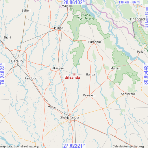
Bilsanda GPS coordinates[2]
28° 14' 36.276" North, 79° 57' 4.86" East
| Map corner | latitude | longitude |
|---|---|---|
| Upper-left | 28.86102°, | 79.24823° |
| Center: | 28.24341°, | 79.95135° |
| Lower-right: | 27.62221°, | 80.65448° |
| Map W x H: | 137.7×137.7 km | = 85.6×85.6mi |
| max Lat: | 34.9274° ⇑14.4% North |
| Bilsanda: | 28.24341° |
| min Lat: | ⇓85.6% South 8.09008° |
| min Long | Bilsanda | max Long |
| 68.82655° | 79.95135° | 96.81° |
| W 67.5%⇐ | ⇒32.5% E |
Elevation
Elevation of Bilsanda is 171 m = 561 ft, and this is 124.6 m = 409 ft below average elevation for this country.
| Max E: |
3681 m = 12077 ft | 55.8% |
| Avg. | 295.6 m = 970 ft | |
| Bilsanda | 171 m = 561 ft | |
Min E: |
1 m = 3 ft | 44.2% |
See also: India elevation on elevation.city.
Geographical zone
Bilsanda is located in North temperate zone (between Tropic of Cancer and the Arctic Circle). Distance of this Northern Tropic circle is 534.5 km =332.1 mi to South.| Distance of | km | miles | from Bilsanda |
|---|---|---|---|
| North Pole | 6866.7 | 4266.8 | to North |
| Arctic Circle | 4260.8 | 2647.5 | to North |
| Tropic Cancer | 534.5 | 332.1 | to South |
| Equator | 3140.4 | 1951.4 | to South |


Nearby cities:
15 places around Bilsanda: (largest is in red/bold)
• Barkhera Kalān
27.2 km =16.9 mi,  328°
328°
• Bīsalpur
15.4 km =9.6 mi,  290°
290°
• Farīdpur
40.3 km =25 mi,  264°
264°
• Khudāganj
25.6 km =15.9 mi,  244°
244°
• Khūtār
31.6 km =19.6 mi,  98°
98°
• Kālīnagar
43.8 km =27.2 mi,  16°
16°
• Mailāni
38.8 km =24.1 mi,  82°
82°
• Mohanpur
28.8 km =17.9 mi,  87°
87°
• Mīrānpur Katra
36.6 km =22.7 mi,  229°
229°
• Nawābganj
45.3 km =28.1 mi,  316°
316°
• Pawāyan
24.7 km =15.3 mi,  142°
142°
• Pīlibhīt
45.5 km =28.3 mi,  341°
341°
• Pūranpur
35.6 km =22.1 mi,  32°
32°
• Shāhjānpur
40.4 km =25.1 mi,  185°
185°
• Tilhar
37.6 km =23.4 mi,  213°
213°
Sources, notices
• [Note1] Compared only with cities in India existing in our database
• [Src1] Map data: © OpenStreetMap contributors (CC-BY-SA)
• [Src2] Other city data from geonames.org with taken over terms of usage.
• [Src3] Geographical zone / Annual Mean Temperature by Robert A. Rohde @ Wikipedia
