Bīsalpur geodata
Bīsalpur (Uttar Pradesh) is a populated place; located in India in Asia/Kolkata (GMT+5.5) time zone. With population of 68,355 people, there are 634 cities with bigger population in this country. Compared to other cities in India, 85.9% of cities are located further ↓South; 66.4% of cities are located further ←West and 55.6% of cities have higher elevation than Bīsalpur. Note1


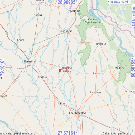
Bīsalpur GPS coordinates[2]
28° 17' 33.108" North, 79° 48' 16.992" East
| Map corner | latitude | longitude |
|---|---|---|
| Upper-left | 28.90985°, | 79.1016° |
| Center: | 28.29253°, | 79.80472° |
| Lower-right: | 27.67161°, | 80.50785° |
| Map W x H: | 137.7×137.7 km | = 85.6×85.6mi |
| max Lat: | 34.9274° ⇑14.1% North |
| Bīsalpur: | 28.29253° |
| min Lat: | ⇓85.9% South 8.09008° |
| min Long | Bīsalpur | max Long |
| 68.82655° | 79.80472° | 96.81° |
| W 66.4%⇐ | ⇒33.6% E |
Elevation
Elevation of Bīsalpur is 172 m = 564 ft, and this is 123.6 m = 406 ft below average elevation for this country.
| Max E: |
3681 m = 12077 ft | 55.6% |
| Avg. | 295.6 m = 970 ft | |
| Bīsalpur | 172 m = 564 ft | |
Min E: |
1 m = 3 ft | 44.4% |
See also: Bīsalpur elevation on elevation.city.
Geographical zone
Bīsalpur is located in North temperate zone (between Tropic of Cancer and the Arctic Circle). Distance of this Northern Tropic circle is 539.9 km =335.5 mi to South.| Distance of | km | miles | from Bīsalpur |
|---|---|---|---|
| North Pole | 6861.2 | 4263.4 | to North |
| Arctic Circle | 4255.3 | 2644.1 | to North |
| Tropic Cancer | 539.9 | 335.5 | to South |
| Equator | 3145.8 | 1954.7 | to South |


Nearby cities:
15 places around Bīsalpur: (largest is in red/bold)
• Bareilly
37.4 km =23.2 mi,  282°
282°
• Barkhera Kalān
17.7 km =11 mi,  0°
0°
• Bilsanda
15.4 km =9.6 mi,  110°
110°
• Farīdpur
27.4 km =17 mi,  250°
250°
• Jahānābād
38.5 km =23.9 mi,  347°
347°
• Khudāganj
18.5 km =11.5 mi,  208°
208°
• Khūtār
46.7 km =29 mi,  102°
102°
• Kālīnagar
45.4 km =28.2 mi,  36°
36°
• Mohanpur
43.3 km =26.9 mi, 95°
• Mīrānpur Katra
32.2 km =20 mi,  204°
204°
• Nawābganj
32.3 km =20.1 mi,  328°
328°
• Pawāyan
38.6 km =24 mi,  130°
130°
• Pīlibhīt
37.7 km =23.4 mi,  359°
359°
• Pūranpur
41.6 km =25.8 mi,  53°
53°
• Tilhar
37.2 km =23.1 mi,  190°
190°
Sources, notices
• [Note1] Compared only with cities in India existing in our database
• [Src1] Map data: © OpenStreetMap contributors (CC-BY-SA)
• [Src2] Other city data from geonames.org with taken over terms of usage.
• [Src3] Geographical zone / Annual Mean Temperature by Robert A. Rohde @ Wikipedia
