Mīrānpur Katra geodata
Mīrānpur Katra (Uttar Pradesh) is a populated place; located in India in Asia/Kolkata (GMT+5.5) time zone. With population of 29,626 people, there are 1466 cities with bigger population in this country. Compared to other cities in India, 84.6% of cities are located further ↓South; 65.4% of cities are located further ←West and 57.2% of cities have higher elevation than Mīrānpur Katra. Note1


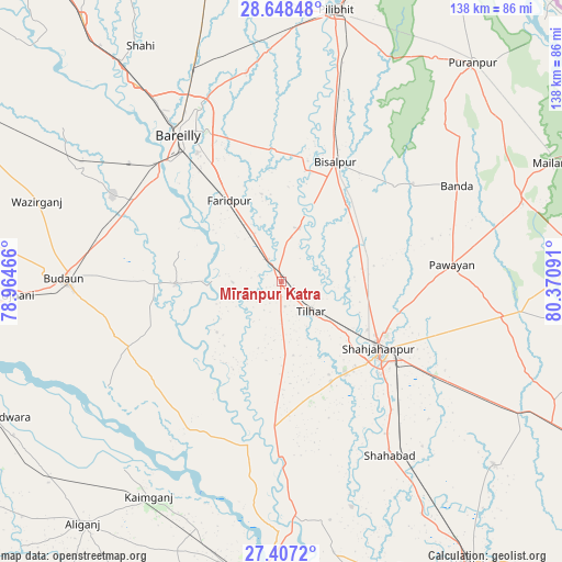
Mīrānpur Katra GPS coordinates[2]
28° 1' 46.668" North, 79° 40' 4.008" East
| Map corner | latitude | longitude |
|---|---|---|
| Upper-left | 28.64848°, | 78.96466° |
| Center: | 28.02963°, | 79.66778° |
| Lower-right: | 27.4072°, | 80.37091° |
| Map W x H: | 138×138 km | = 85.7×85.7mi |
| max Lat: | 34.9274° ⇑15.4% North |
| Mīrānpur Katra: | 28.02963° |
| min Lat: | ⇓84.6% South 8.09008° |
| min Long | Mīrānpur Katr | max Long |
| 68.82655° | 79.66778° | 96.81° |
| W 65.4%⇐ | ⇒34.6% E |
Elevation
Elevation of Mīrānpur Katra is 162 m = 531 ft, and this is 133.6 m = 438 ft below average elevation for this country.
| Max E: |
3681 m = 12077 ft | 57.2% |
| Avg. | 295.6 m = 970 ft | |
| Mīrānpur Katra | 162 m = 531 ft | |
Min E: |
1 m = 3 ft | 42.8% |
See also: India elevation on elevation.city.
Geographical zone
Mīrānpur Katra is located in North temperate zone (between Tropic of Cancer and the Arctic Circle). Distance of this Northern Tropic circle is 510.7 km =317.3 mi to South.| Distance of | km | miles | from Mīrānpur Katra |
|---|---|---|---|
| North Pole | 6890.5 | 4281.6 | to North |
| Arctic Circle | 4284.6 | 2662.3 | to North |
| Tropic Cancer | 510.7 | 317.3 | to South |
| Equator | 3116.6 | 1936.6 | to South |


Nearby cities:
15 places around Mīrānpur Katra: (largest is in red/bold)
• Bareilly
44.1 km =27.4 mi,  328°
328°
• Barkhera Kalān
48.9 km =30.4 mi,  16°
16°
• Bilsanda
36.6 km =22.7 mi,  49°
49°
• Bīsalpur
32.2 km =20 mi, 24°
• Dātāganj
25.5 km =15.8 mi,  268°
268°
• Farīdpur
23.6 km =14.7 mi, 328°
• Jalālābād
33.8 km =21 mi,  182°
182°
• Kakrāla
48.9 km =30.4 mi,  251°
251°
• Khudāganj
13.7 km =8.5 mi, 19°
• Kānt
27.2 km =16.9 mi,  153°
153°
• Pawāyan
42.9 km =26.7 mi,  84°
84°
• Shāhjānpur
28.9 km =18 mi,  124°
124°
• Shāhābād
50.6 km =31.4 mi, 148°
• Tilhar
10.2 km =6.3 mi,  137°
137°
• Usehat
49.5 km =30.8 mi,  238°
238°
Sources, notices
• [Note1] Compared only with cities in India existing in our database
• [Src1] Map data: © OpenStreetMap contributors (CC-BY-SA)
• [Src2] Other city data from geonames.org with taken over terms of usage.
• [Src3] Geographical zone / Annual Mean Temperature by Robert A. Rohde @ Wikipedia
