Khudāganj geodata
Khudāganj (Uttar Pradesh) is a populated place; located in India in Asia/Kolkata (GMT+5.5) time zone. With population of 12,636 people, there are 2690 cities with bigger population in this country. Compared to other cities in India, 85.1% of cities are located further ↓South; 65.8% of cities are located further ←West and 56.7% of cities have higher elevation than Khudāganj. Note1


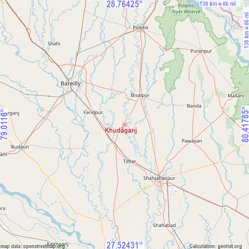
Khudāganj GPS coordinates[2]
28° 8' 45.852" North, 79° 42' 52.992" East
| Map corner | latitude | longitude |
|---|---|---|
| Upper-left | 28.76425°, | 79.0116° |
| Center: | 28.14607°, | 79.71472° |
| Lower-right: | 27.52431°, | 80.41785° |
| Map W x H: | 137.9×137.9 km | = 85.7×85.7mi |
| max Lat: | 34.9274° ⇑14.9% North |
| Khudāganj: | 28.14607° |
| min Lat: | ⇓85.1% South 8.09008° |
| min Long | Khudāganj | max Long |
| 68.82655° | 79.71472° | 96.81° |
| W 65.8%⇐ | ⇒34.2% E |
Elevation
Elevation of Khudāganj is 166 m = 545 ft, and this is 129.6 m = 425 ft below average elevation for this country.
| Max E: |
3681 m = 12077 ft | 56.7% |
| Avg. | 295.6 m = 970 ft | |
| Khudāganj | 166 m = 545 ft | |
Min E: |
1 m = 3 ft | 43.3% |
See also: India elevation on elevation.city.
Geographical zone
Khudāganj is located in North temperate zone (between Tropic of Cancer and the Arctic Circle). Distance of this Northern Tropic circle is 523.6 km =325.3 mi to South.| Distance of | km | miles | from Khudāganj |
|---|---|---|---|
| North Pole | 6877.5 | 4273.5 | to North |
| Arctic Circle | 4271.6 | 2654.2 | to North |
| Tropic Cancer | 523.6 | 325.3 | to South |
| Equator | 3129.5 | 1944.6 | to South |


Nearby cities:
15 places around Khudāganj: (largest is in red/bold)
• Bareilly
37 km =23 mi,  311°
311°
• Barkhera Kalān
35.2 km =21.9 mi,  14°
14°
• Bilsanda
25.6 km =15.9 mi,  64°
64°
• Bīsalpur
18.5 km =11.5 mi,  28°
28°
• Dātāganj
32.9 km =20.4 mi,  245°
245°
• Farīdpur
18.4 km =11.4 mi,  292°
292°
• Fatehganj West
53.5 km =33.2 mi, 311°
• Jalālābād
47 km =29.2 mi,  187°
187°
• Kānt
38.1 km =23.7 mi,  168°
168°
• Mohanpur
53.3 km =33.1 mi,  77°
77°
• Mīrānpur Katra
13.7 km =8.5 mi,  199°
199°
• Nawābganj
44.6 km =27.7 mi,  349°
349°
• Pawāyan
39.1 km =24.3 mi,  103°
103°
• Shāhjānpur
35.1 km =21.8 mi,  147°
147°
• Tilhar
20.5 km =12.7 mi, 173°
Sources, notices
• [Note1] Compared only with cities in India existing in our database
• [Src1] Map data: © OpenStreetMap contributors (CC-BY-SA)
• [Src2] Other city data from geonames.org with taken over terms of usage.
• [Src3] Geographical zone / Annual Mean Temperature by Robert A. Rohde @ Wikipedia
