Dhāruhera geodata
Dhāruhera (Haryana) is a populated place; located in India in Asia/Kolkata (GMT+5.5) time zone. With population of 23,132 people, there are 1827 cities with bigger population in this country. Compared to other cities in India, 85.4% of cities are located further ↓South; 65.1% of cities are located further →East and 60.5% of cities have lower elevation than Dhāruhera. Note1


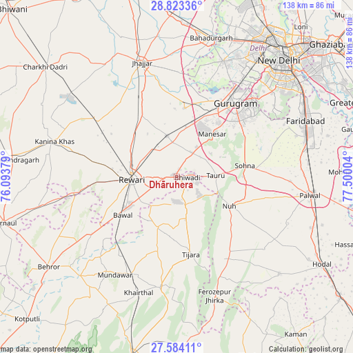
Dhāruhera GPS coordinates[2]
28° 12' 19.908" North, 76° 47' 48.876" East
| Map corner | latitude | longitude |
|---|---|---|
| Upper-left | 28.82336°, | 76.09379° |
| Center: | 28.20553°, | 76.79691° |
| Lower-right: | 27.58411°, | 77.50004° |
| Map W x H: | 137.8×137.8 km | = 85.6×85.6mi |
| max Lat: | 34.9274° ⇑14.6% North |
| Dhāruhera: | 28.20553° |
| min Lat: | ⇓85.4% South 8.09008° |
| min Long | Dhāruhera | max Long |
| 68.82655° | 76.79691° | 96.81° |
| W 34.9%⇐ | ⇒65.1% E |
Elevation
Elevation of Dhāruhera is 255 m = 837 ft, and this is 40.6 m = 133 ft below average elevation for this country.
| Max E: |
3681 m = 12077 ft | 39.5% |
| Avg. | 295.6 m = 970 ft | |
| Dhāruhera | 255 m = 837 ft | |
Min E: |
1 m = 3 ft | 60.5% |
See also: India elevation on elevation.city.
Geographical zone
Dhāruhera is located in North temperate zone (between Tropic of Cancer and the Arctic Circle). Distance of this Northern Tropic circle is 530.2 km =329.5 mi to South.| Distance of | km | miles | from Dhāruhera |
|---|---|---|---|
| North Pole | 6870.9 | 4269.4 | to North |
| Arctic Circle | 4265 | 2650.1 | to North |
| Tropic Cancer | 530.2 | 329.5 | to South |
| Equator | 3136.2 | 1948.7 | to South |


Nearby cities:
15 places around Dhāruhera: (largest is in red/bold)
• Bhiwadi
6.3 km =3.9 mi,  85°
85°
• Bāwal
25.7 km =16 mi,  234°
234°
• Farrukhnagar
27 km =16.8 mi,  5°
5°
• Fīrozpur Jhirka
48.6 km =30.2 mi,  162°
162°
• Gurgaon
36.1 km =22.4 mi,  38°
38°
• Jhajjar
46.6 km =29 mi,  342°
342°
• Kishangarh
43.5 km =27 mi,  188°
188°
• Mandāwar
45.1 km =28 mi,  212°
212°
• Najafgarh
48.3 km =30 mi,  21°
21°
• Nūh
23.1 km =14.4 mi,  119°
119°
• Pataudi
13.5 km =8.4 mi,  352°
352°
• Rewāri
17.5 km =10.9 mi,  267°
267°
• Sohna
26.7 km =16.6 mi,  79°
79°
• Tijāra
30.7 km =19.1 mi,  169°
169°
• Tāoru
15 km =9.3 mi, 87°
Sources, notices
• [Note1] Compared only with cities in India existing in our database
• [Src1] Map data: © OpenStreetMap contributors (CC-BY-SA)
• [Src2] Other city data from geonames.org with taken over terms of usage.
• [Src3] Geographical zone / Annual Mean Temperature by Robert A. Rohde @ Wikipedia
