Rewāri geodata
Rewāri (Haryana) is a populated place; located in India in Asia/Kolkata (GMT+5.5) time zone. With population of 112,079 people, there are 395 cities with bigger population in this country. Compared to other cities in India, 85.3% of cities are located further ↓South; 67% of cities are located further →East and 61.2% of cities have lower elevation than Rewāri. Note1


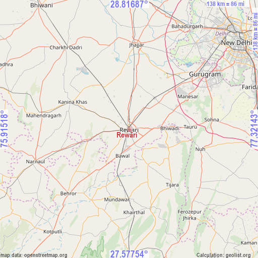
Rewāri GPS coordinates[2]
28° 11' 56.4" North, 76° 37' 5.88" East
| Map corner | latitude | longitude |
|---|---|---|
| Upper-left | 28.81687°, | 75.91518° |
| Center: | 28.199°, | 76.6183° |
| Lower-right: | 27.57754°, | 77.32143° |
| Map W x H: | 137.8×137.8 km | = 85.6×85.6mi |
| max Lat: | 34.9274° ⇑14.7% North |
| Rewāri: | 28.199° |
| min Lat: | ⇓85.3% South 8.09008° |
| min Long | Rewāri | max Long |
| 68.82655° | 76.6183° | 96.81° |
| W 33%⇐ | ⇒67% E |
Elevation
Elevation of Rewāri is 259 m = 850 ft, and this is 36.6 m = 120 ft below average elevation for this country.
| Max E: |
3681 m = 12077 ft | 38.8% |
| Avg. | 295.6 m = 970 ft | |
| Rewāri | 259 m = 850 ft | |
Min E: |
1 m = 3 ft | 61.2% |
See also: Rewāri elevation on elevation.city.
Geographical zone
Rewāri is located in North temperate zone (between Tropic of Cancer and the Arctic Circle). Distance of this Northern Tropic circle is 529.5 km =329 mi to South.| Distance of | km | miles | from Rewāri |
|---|---|---|---|
| North Pole | 6871.6 | 4269.8 | to North |
| Arctic Circle | 4265.7 | 2650.6 | to North |
| Tropic Cancer | 529.5 | 329 | to South |
| Equator | 3135.4 | 1948.2 | to South |


Nearby cities:
15 places around Rewāri: (largest is in red/bold)
• Ateli Mandi
36.8 km =22.9 mi,  252°
252°
• Bhiwadi
23.8 km =14.8 mi,  86°
86°
• Bāwal
14.6 km =9.1 mi,  193°
193°
• Dhāruhera
17.5 km =10.9 mi, 87°
• Farrukhnagar
34.2 km =21.3 mi,  36°
36°
• Jhajjar
45.4 km =28.2 mi,  4°
4°
• Kanīna Khās
33.5 km =20.8 mi,  295°
295°
• Kishangarh
43.7 km =27.2 mi,  165°
165°
• Mahendragarh
46.3 km =28.8 mi,  279°
279°
• Mandāwar
37.9 km =23.5 mi, 190°
• Nūh
39.1 km =24.3 mi,  105°
105°
• Pataudi
21.1 km =13.1 mi,  48°
48°
• Sohna
44.1 km =27.4 mi,  83°
83°
• Tijāra
37.5 km =23.3 mi,  141°
141°
• Tāoru
32.5 km =20.2 mi, 87°
Sources, notices
• [Note1] Compared only with cities in India existing in our database
• [Src1] Map data: © OpenStreetMap contributors (CC-BY-SA)
• [Src2] Other city data from geonames.org with taken over terms of usage.
• [Src3] Geographical zone / Annual Mean Temperature by Robert A. Rohde @ Wikipedia
