Sohna geodata
Sohna (Haryana) is a populated place; located in India in Asia/Kolkata (GMT+5.5) time zone. With population of 33,361 people, there are 1305 cities with bigger population in this country. Compared to other cities in India, 85.6% of cities are located further ↓South; 62.3% of cities are located further →East and 51.7% of cities have lower elevation than Sohna. Note1


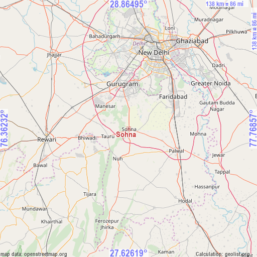
Sohna GPS coordinates[2]
28° 14' 50.532" North, 77° 3' 55.584" East
| Map corner | latitude | longitude |
|---|---|---|
| Upper-left | 28.86495°, | 76.36232° |
| Center: | 28.24737°, | 77.06544° |
| Lower-right: | 27.62619°, | 77.76857° |
| Map W x H: | 137.7×137.7 km | = 85.6×85.6mi |
| max Lat: | 34.9274° ⇑14.4% North |
| Sohna: | 28.24737° |
| min Lat: | ⇓85.6% South 8.09008° |
| min Long | Sohna | max Long |
| 68.82655° | 77.06544° | 96.81° |
| W 37.7%⇐ | ⇒62.3% E |
Elevation
Elevation of Sohna is 212 m = 696 ft, and this is 83.6 m = 274 ft below average elevation for this country.
| Max E: |
3681 m = 12077 ft | 48.3% |
| Avg. | 295.6 m = 970 ft | |
| Sohna | 212 m = 696 ft | |
Min E: |
1 m = 3 ft | 51.7% |
See also: India elevation on elevation.city.
Geographical zone
Sohna is located in North temperate zone (between Tropic of Cancer and the Arctic Circle). Distance of this Northern Tropic circle is 534.9 km =332.4 mi to South.| Distance of | km | miles | from Sohna |
|---|---|---|---|
| North Pole | 6866.2 | 4266.5 | to North |
| Arctic Circle | 4260.4 | 2647.3 | to North |
| Tropic Cancer | 534.9 | 332.4 | to South |
| Equator | 3140.8 | 1951.6 | to South |


Nearby cities:
15 places around Sohna: (largest is in red/bold)
• Bhiwadi
20.5 km =12.7 mi,  258°
258°
• Defence Colony
39.6 km =24.6 mi,  24°
24°
• Deoli
32.7 km =20.3 mi,  29°
29°
• Dhāruhera
26.7 km =16.6 mi, 259°
• Faridabad
30.3 km =18.8 mi,  53°
53°
• Farrukhnagar
32.5 km =20.2 mi,  313°
313°
• Gurgaon
24 km =14.9 mi,  350°
350°
• Najafgarh
41.1 km =25.5 mi, 348°
• Nūh
17.2 km =10.7 mi,  201°
201°
• Palwal
27.9 km =17.3 mi,  114°
114°
• Pataudi
29.4 km =18.3 mi,  287°
287°
• Sector
44.1 km =27.4 mi,  35°
35°
• Shahdara
40.2 km =25 mi,  10°
10°
• Tijāra
40.5 km =25.2 mi,  210°
210°
• Tāoru
12 km =7.5 mi,  250°
250°
Sources, notices
• [Note1] Compared only with cities in India existing in our database
• [Src1] Map data: © OpenStreetMap contributors (CC-BY-SA)
• [Src2] Other city data from geonames.org with taken over terms of usage.
• [Src3] Geographical zone / Annual Mean Temperature by Robert A. Rohde @ Wikipedia
