Rajaori geodata
Rajaori (Jammu and Kashmir) is a populated place; located in India in Asia/Kolkata (GMT+5.5) time zone. With population of 27,792 people, there are 1552 cities with bigger population in this country. Compared to other cities in India, 99.1% of cities are located further ↓South; 87.9% of cities are located further →East and 95.6% of cities have lower elevation than Rajaori. Note1


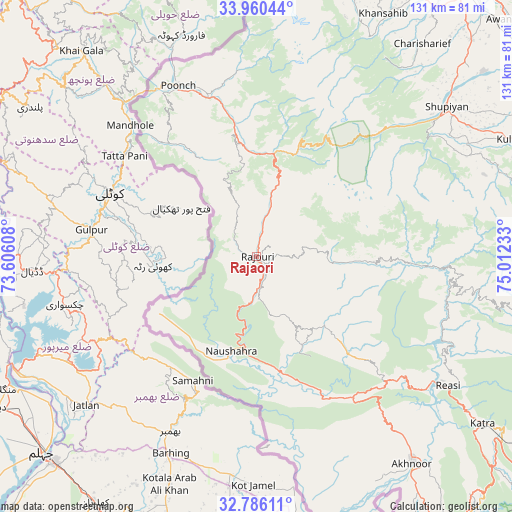
Rajaori GPS coordinates[2]
33° 22' 30.936" North, 74° 18' 33.12" East
| Map corner | latitude | longitude |
|---|---|---|
| Upper-left | 33.96044°, | 73.60608° |
| Center: | 33.37526°, | 74.3092° |
| Lower-right: | 32.78611°, | 75.01233° |
| Map W x H: | 130.6×130.6 km | = 81.2×81.2mi |
| max Lat: | 34.9274° ⇑0.9% North |
| Rajaori: | 33.37526° |
| min Lat: | ⇓99.1% South 8.09008° |
| min Long | Rajaori | max Long |
| 68.82655° | 74.3092° | 96.81° |
| W 12.1%⇐ | ⇒87.9% E |
Elevation
Elevation of Rajaori is 924 m = 3031 ft, and this is 628.4 m = 2062 ft above average elevation for this country.
| Max E: |
3681 m = 12077 ft | 4.4% |
| Rajaori | 924 m 3031 ft | |
| Avg. | 295.6 m = 970 ft | |
Min E: |
1 m = 3 ft | 95.6% |
See also: India elevation on elevation.city.
Geographical zone
Rajaori is located in North temperate zone (between Tropic of Cancer and the Arctic Circle). Distance of this Northern Tropic circle is 1105.1 km =686.7 mi to South.| Distance of | km | miles | from Rajaori |
|---|---|---|---|
| North Pole | 6296.1 | 3912.2 | to North |
| Arctic Circle | 3690.2 | 2293 | to North |
| Tropic Cancer | 1105.1 | 686.7 | to South |
| Equator | 3711 | 2305.9 | to South |


Nearby cities:
15 places around Rajaori: (largest is in red/bold)
• Akhnūr
69 km =42.9 mi,  145°
145°
• Gulmarg
75.7 km =47 mi,  5°
5°
• Jauriān
65.3 km =40.6 mi,  157°
157°
• Katra
72 km =44.7 mi,  126°
126°
• Kulgam
72.3 km =44.9 mi,  65°
65°
• Kupwāra
73 km =45.4 mi,  356°
356°
• Nawānshahr
70.8 km =44 mi, 163°
• Pulwama
77.9 km =48.4 mi,  44°
44°
• Pūnch
48.3 km =30 mi,  335°
335°
• Riāsi
58.6 km =36.4 mi,  123°
123°
• Rāmgarh
8.5 km =5.3 mi,  291°
291°
• Shupīyan
61.7 km =38.3 mi,  51°
51°
• Thanna Mandi
19.7 km =12.2 mi,  19°
19°
• Tsrār Sharīf
68.7 km =42.7 mi, 37°
• Uri
82 km =51 mi, 343°
Sources, notices
• [Note1] Compared only with cities in India existing in our database
• [Src1] Map data: © OpenStreetMap contributors (CC-BY-SA)
• [Src2] Other city data from geonames.org with taken over terms of usage.
• [Src3] Geographical zone / Annual Mean Temperature by Robert A. Rohde @ Wikipedia
