Pehowa geodata
Pehowa (Haryana) is a populated place; located in India in Asia/Kolkata (GMT+5.5) time zone. With population of 39,101 people, there are 1129 cities with bigger population in this country. Compared to other cities in India, 92.8% of cities are located further ↓South; 67.4% of cities are located further →East and 61.4% of cities have lower elevation than Pehowa. Note1


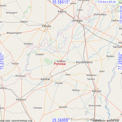
Pehowa GPS coordinates[2]
29° 58' 44.292" North, 76° 34' 56.964" East
| Map corner | latitude | longitude |
|---|---|---|
| Upper-left | 30.58615°, | 75.87937° |
| Center: | 29.97897°, | 76.58249° |
| Lower-right: | 29.36806°, | 77.28562° |
| Map W x H: | 135.4×135.4 km | = 84.1×84.1mi |
| max Lat: | 34.9274° ⇑7.2% North |
| Pehowa: | 29.97897° |
| min Lat: | ⇓92.8% South 8.09008° |
| min Long | Pehowa | max Long |
| 68.82655° | 76.58249° | 96.81° |
| W 32.6%⇐ | ⇒67.4% E |
Elevation
Elevation of Pehowa is 261 m = 856 ft, and this is 34.6 m = 114 ft below average elevation for this country.
| Max E: |
3681 m = 12077 ft | 38.6% |
| Avg. | 295.6 m = 970 ft | |
| Pehowa | 261 m = 856 ft | |
Min E: |
1 m = 3 ft | 61.4% |
See also: India elevation on elevation.city.
Geographical zone
Pehowa is located in North temperate zone (between Tropic of Cancer and the Arctic Circle). Distance of this Northern Tropic circle is 727.4 km =452 mi to South.| Distance of | km | miles | from Pehowa |
|---|---|---|---|
| North Pole | 6673.7 | 4146.8 | to North |
| Arctic Circle | 4067.8 | 2527.6 | to North |
| Tropic Cancer | 727.4 | 452 | to South |
| Equator | 3333.3 | 2071.2 | to South |


Nearby cities:
15 places around Pehowa: (largest is in red/bold)
• Ambāla
47.3 km =29.4 mi,  25°
25°
• Ghanaur
39.2 km =24.4 mi,  4°
4°
• Indri
47.3 km =29.4 mi,  103°
103°
• Kaithal
26.5 km =16.5 mi,  221°
221°
• Karnāl
50.2 km =31.2 mi,  129°
129°
• Lādwa
44.6 km =27.7 mi,  87°
87°
• Nīlokheri
37.2 km =23.1 mi,  115°
115°
• Patiāla
43.7 km =27.2 mi,  335°
335°
• Pūndri
24.3 km =15.1 mi,  185°
185°
• Radaur
55.1 km =34.2 mi,  84°
84°
• Rājpura
55.6 km =34.5 mi, 1°
• Sanaur
37.8 km =23.5 mi, 341°
• Shāhābād
34.8 km =21.6 mi,  52°
52°
• Thānesar
24.1 km =15 mi, 91°
• Āsandh
50.9 km =31.6 mi,  177°
177°
Sources, notices
• [Note1] Compared only with cities in India existing in our database
• [Src1] Map data: © OpenStreetMap contributors (CC-BY-SA)
• [Src2] Other city data from geonames.org with taken over terms of usage.
• [Src3] Geographical zone / Annual Mean Temperature by Robert A. Rohde @ Wikipedia
