Kaithal geodata
Kaithal (Haryana) is a populated place; located in India in Asia/Kolkata (GMT+5.5) time zone. With population of 140,604 people, there are 305 cities with bigger population in this country. Compared to other cities in India, 92.2% of cities are located further ↓South; 69.1% of cities are located further →East and 56.5% of cities have lower elevation than Kaithal. Note1


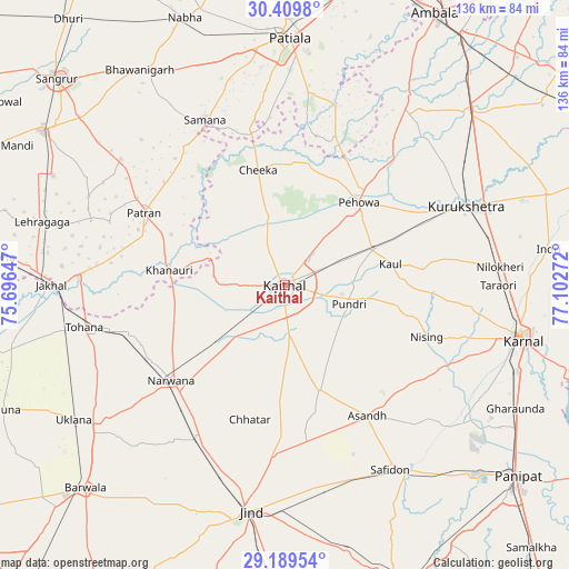
Kaithal GPS coordinates[2]
29° 48' 5.508" North, 76° 23' 58.524" East
| Map corner | latitude | longitude |
|---|---|---|
| Upper-left | 30.4098°, | 75.69647° |
| Center: | 29.80153°, | 76.39959° |
| Lower-right: | 29.18954°, | 77.10272° |
| Map W x H: | 135.7×135.7 km | = 84.3×84.3mi |
| max Lat: | 34.9274° ⇑7.8% North |
| Kaithal: | 29.80153° |
| min Lat: | ⇓92.2% South 8.09008° |
| min Long | Kaithal | max Long |
| 68.82655° | 76.39959° | 96.81° |
| W 30.9%⇐ | ⇒69.1% E |
Elevation
Elevation of Kaithal is 232 m = 761 ft, and this is 63.6 m = 209 ft below average elevation for this country.
| Max E: |
3681 m = 12077 ft | 43.5% |
| Avg. | 295.6 m = 970 ft | |
| Kaithal | 232 m = 761 ft | |
Min E: |
1 m = 3 ft | 56.5% |
See also: Kaithal elevation on elevation.city.
Geographical zone
Kaithal is located in North temperate zone (between Tropic of Cancer and the Arctic Circle). Distance of this Northern Tropic circle is 707.7 km =439.7 mi to South.| Distance of | km | miles | from Kaithal |
|---|---|---|---|
| North Pole | 6693.4 | 4159.1 | to North |
| Arctic Circle | 4087.6 | 2539.9 | to North |
| Tropic Cancer | 707.7 | 439.7 | to South |
| Equator | 3313.6 | 2059 | to South |


Nearby cities:
15 places around Kaithal: (largest is in red/bold)
• Akālgarh
49.1 km =30.5 mi,  272°
272°
• Bara Uchāna
42.9 km =26.7 mi,  209°
209°
• Dirba
49.2 km =30.6 mi,  307°
307°
• Jākhal
55.5 km =34.5 mi, 269°
• Jīnd
54.6 km =33.9 mi,  188°
188°
• Karnāl
57.8 km =35.9 mi,  102°
102°
• Narwāna
35.2 km =21.9 mi,  230°
230°
• Nīlokheri
51.5 km =32 mi,  85°
85°
• Pehowa
26.5 km =16.5 mi,  41°
41°
• Pūndri
16.2 km =10.1 mi,  106°
106°
• Safidon
51.2 km =31.8 mi,  149°
149°
• Sanaur
55.9 km =34.7 mi,  5°
5°
• Thānesar
45.9 km =28.5 mi,  65°
65°
• Tohāna
48.8 km =30.3 mi,  258°
258°
• Āsandh
37 km =23 mi, 147°
Sources, notices
• [Note1] Compared only with cities in India existing in our database
• [Src1] Map data: © OpenStreetMap contributors (CC-BY-SA)
• [Src2] Other city data from geonames.org with taken over terms of usage.
• [Src3] Geographical zone / Annual Mean Temperature by Robert A. Rohde @ Wikipedia
