Halvad geodata
Halvad (Gujarat) is a populated place; located in India in Asia/Kolkata (GMT+5.5) time zone. With population of 26,205 people, there are 1627 cities with bigger population in this country. Compared to other cities in India, 51.8% of cities are located further ↓South; 98.4% of cities are located further →East and 80.7% of cities have higher elevation than Halvad. Note1


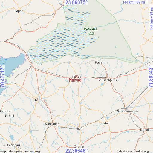
Halvad GPS coordinates[2]
23° 0' 54.576" North, 71° 10' 49.044" East
| Map corner | latitude | longitude |
|---|---|---|
| Upper-left | 23.66075°, | 70.47717° |
| Center: | 23.01516°, | 71.18029° |
| Lower-right: | 22.36646°, | 71.88342° |
| Map W x H: | 143.9×143.9 km | = 89.4×89.4mi |
| max Lat: | 34.9274° ⇑48.2% North |
| Halvad: | 23.01516° |
| min Lat: | ⇓51.8% South 8.09008° |
| min Long | Halvad | max Long |
| 68.82655° | 71.18029° | 96.81° |
| W 1.6%⇐ | ⇒98.4% E |
Elevation
Elevation of Halvad is 45 m = 148 ft, and this is 250.6 m = 822 ft below average elevation for this country.
| Max E: |
3681 m = 12077 ft | 80.7% |
| Avg. | 295.6 m = 970 ft | |
| Halvad | 45 m = 148 ft | |
Min E: |
1 m = 3 ft | 19.3% |
See also: India elevation on elevation.city.
Geographical zone
Halvad is located in North Torrid zone (between Equator and Tropic of Cancer). Distance of this Northern Tropic circle is 46.9 km =29.1 mi to North.| Distance of | km | miles | from Halvad |
|---|---|---|---|
| North Pole | 7448 | 4628 | to North |
| Arctic Circle | 4842.1 | 3008.7 | to North |
| Tropic Cancer | 46.9 | 29.1 | to North |
| Equator | 2559 | 1590.1 | to South |


Nearby cities:
15 places around Halvad: (largest is in red/bold)
• Bhachāu
91.2 km =56.7 mi,  290°
290°
• Chotila
65.8 km =40.9 mi,  178°
178°
• Dhrāngadhra
29.6 km =18.4 mi,  95°
95°
• Lakhtar
64.7 km =40.2 mi,  105°
105°
• Limbdi
81.7 km =50.8 mi,  127°
127°
• Morbi
41.4 km =25.7 mi,  237°
237°
• Māndal
81.4 km =50.6 mi,  68°
68°
• Paddhari
87.5 km =54.4 mi,  222°
222°
• Rājkot
89.7 km =55.7 mi,  206°
206°
• Rāpar
82.5 km =51.3 mi,  318°
318°
• Surendranagar
57.7 km =35.9 mi,  123°
123°
• Sāyla
60.4 km =37.5 mi,  149°
149°
• Tankāra
59.5 km =37 mi,  227°
227°
• Thān
49.1 km =30.5 mi, 177°
• Wānkāner
51 km =31.7 mi, 208°
Sources, notices
• [Note1] Compared only with cities in India existing in our database
• [Src1] Map data: © OpenStreetMap contributors (CC-BY-SA)
• [Src2] Other city data from geonames.org with taken over terms of usage.
• [Src3] Geographical zone / Annual Mean Temperature by Robert A. Rohde @ Wikipedia
