Sāyla geodata
Sāyla (Gujarat) is a populated place; located in India in Asia/Kolkata (GMT+5.5) time zone. With population of 15,376 people, there are 2427 cities with bigger population in this country. Compared to other cities in India, 52.7% of cities are located further ↑North; 98% of cities are located further →East and 62.5% of cities have higher elevation than Sāyla. Note1


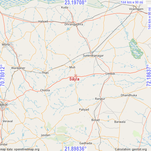
Sāyla GPS coordinates[2]
22° 32' 57.3" North, 71° 28' 59.664" East
| Map corner | latitude | longitude |
|---|---|---|
| Upper-left | 23.19708°, | 70.78012° |
| Center: | 22.54925°, | 71.48324° |
| Lower-right: | 21.89836°, | 72.18637° |
| Map W x H: | 144.4×144.4 km | = 89.7×89.7mi |
| max Lat: | 34.9274° ⇑52.7% North |
| Sāyla: | 22.54925° |
| min Lat: | ⇓47.3% South 8.09008° |
| min Long | Sāyla | max Long |
| 68.82655° | 71.48324° | 96.81° |
| W 2%⇐ | ⇒98% E |
Elevation
Elevation of Sāyla is 135 m = 443 ft, and this is 160.6 m = 527 ft below average elevation for this country.
| Max E: |
3681 m = 12077 ft | 62.5% |
| Avg. | 295.6 m = 970 ft | |
| Sāyla | 135 m = 443 ft | |
Min E: |
1 m = 3 ft | 37.5% |
See also: India elevation on elevation.city.
Geographical zone
Sāyla is located in North Torrid zone (between Equator and Tropic of Cancer). Distance of this Northern Tropic circle is 98.7 km =61.3 mi to North.| Distance of | km | miles | from Sāyla |
|---|---|---|---|
| North Pole | 7499.8 | 4660.2 | to North |
| Arctic Circle | 4893.9 | 3040.9 | to North |
| Tropic Cancer | 98.7 | 61.3 | to North |
| Equator | 2507.2 | 1557.9 | to South |


Nearby cities:
15 places around Sāyla: (largest is in red/bold)
• Botād
46.3 km =28.8 mi,  155°
155°
• Chotila
32.6 km =20.3 mi,  244°
244°
• Dhandhuka
55 km =34.2 mi,  109°
109°
• Dhrāngadhra
49.2 km =30.6 mi,  358°
358°
• Gadhada
65.2 km =40.5 mi,  171°
171°
• Halvad
60.4 km =37.5 mi,  329°
329°
• Jasdan
63.6 km =39.5 mi,  206°
206°
• Lakhtar
46.4 km =28.8 mi,  42°
42°
• Limbdi
33.7 km =20.9 mi,  87°
87°
• Morbi
72.6 km =45.1 mi,  294°
294°
• Pāliyād
33.4 km =20.8 mi, 166°
• Surendranagar
26.1 km =16.2 mi, 40°
• Thān
29.3 km =18.2 mi,  275°
275°
• Vinchia
39.2 km =24.4 mi,  195°
195°
• Wānkāner
55.8 km =34.7 mi, 277°
Sources, notices
• [Note1] Compared only with cities in India existing in our database
• [Src1] Map data: © OpenStreetMap contributors (CC-BY-SA)
• [Src2] Other city data from geonames.org with taken over terms of usage.
• [Src3] Geographical zone / Annual Mean Temperature by Robert A. Rohde @ Wikipedia
