Karanpur geodata
Karanpur (Rajasthan) is a populated place; located in India in Asia/Kolkata (GMT+5.5) time zone. With population of 21,604 people, there are 1926 cities with bigger population in this country. Compared to other cities in India, 92.4% of cities are located further ↓South; 92.8% of cities are located further →East and 56.4% of cities have higher elevation than Karanpur. Note1


Karanpur GPS coordinates[2]
29° 50' 25.512" North, 73° 27' 18.684" East
| Map corner | latitude | longitude |
|---|---|---|
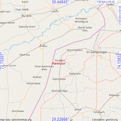
| Upper-left | 30.44845°, | 72.75207° |
| Center: | 29.84042°, | 73.45519° |
| Lower-right: | 29.22866°, | 74.15832° |
| Map W x H: | 135.6×135.6 km | = 84.3×84.3mi |
| max Lat: | 34.9274° ⇑7.6% North |
| Karanpur: | 29.84042° |
| min Lat: | ⇓92.4% South 8.09008° |
| min Long | Karanpur | max Long |
| 68.82655° | 73.45519° | 96.81° |
| W 7.2%⇐ | ⇒92.8% E |
Elevation
Elevation of Karanpur is 168 m = 551 ft, and this is 127.6 m = 419 ft below average elevation for this country.
| Max E: |
3681 m = 12077 ft | 56.4% |
| Avg. | 295.6 m = 970 ft | |
| Karanpur | 168 m = 551 ft | |
Min E: |
1 m = 3 ft | 43.6% |
See also: India elevation on elevation.city.
Geographical zone
Karanpur is located in North temperate zone (between Tropic of Cancer and the Arctic Circle). Distance of this Northern Tropic circle is 712 km =442.4 mi to South.| Distance of | km | miles | from Karanpur |
|---|---|---|---|
| North Pole | 6689.1 | 4156.4 | to North |
| Arctic Circle | 4083.2 | 2537.2 | to North |
| Tropic Cancer | 712 | 442.4 | to South |
| Equator | 3317.9 | 2061.6 | to South |


Nearby cities:
15 places around Karanpur: (largest is in red/bold)
• Abohar
78.9 km =49 mi,  64°
64°
• Anūpgarh
76 km =47.2 mi,  198°
198°
• Fāzilka
83.3 km =51.8 mi,  41°
41°
• Gangānagar
41.4 km =25.7 mi,  77°
77°
• Giddarbāha
123.2 km =76.6 mi,  71°
71°
• Hanumāngarh
89.2 km =55.4 mi,  108°
108°
• Jalālābād
114.8 km =71.3 mi, 42°
• Malaut
107.1 km =66.5 mi, 67°
• Muktsar
124 km =77.1 mi, 55°
• Padampur
22 km =13.7 mi,  131°
131°
• Pilibangan
76 km =47.2 mi,  124°
124°
• Rāisinghnagar
33.9 km =21.1 mi,  180°
180°
• Rāwatsār
111.6 km =69.3 mi, 124°
• Sangariā
97.7 km =60.7 mi,  92°
92°
• Sūratgarh
72 km =44.7 mi,  143°
143°
Sources, notices
• [Note1] Compared only with cities in India existing in our database
• [Src1] Map data: © OpenStreetMap contributors (CC-BY-SA)
• [Src2] Other city data from geonames.org with taken over terms of usage.
• [Src3] Geographical zone / Annual Mean Temperature by Robert A. Rohde @ Wikipedia
