Rāisinghnagar geodata
Rāisinghnagar (Rajasthan) is a populated place; located in India in Asia/Kolkata (GMT+5.5) time zone. With population of 29,626 people, there are 1466 cities with bigger population in this country. Compared to other cities in India, 91.3% of cities are located further ↓South; 92.8% of cities are located further →East and 56.7% of cities have higher elevation than Rāisinghnagar. Note1


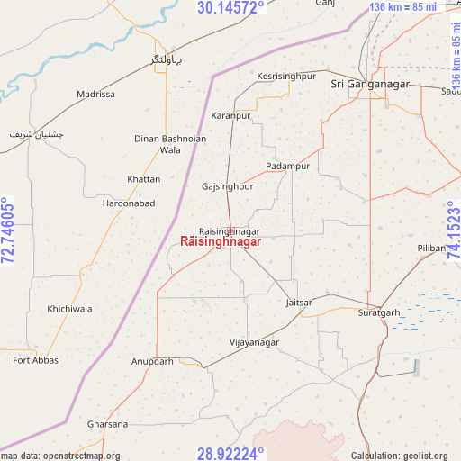
Rāisinghnagar GPS coordinates[2]
29° 32' 8.988" North, 73° 26' 57.012" East
| Map corner | latitude | longitude |
|---|---|---|
| Upper-left | 30.14572°, | 72.74605° |
| Center: | 29.53583°, | 73.44917° |
| Lower-right: | 28.92224°, | 74.1523° |
| Map W x H: | 136×136 km | = 84.5×84.5mi |
| max Lat: | 34.9274° ⇑8.7% North |
| Rāisinghnagar: | 29.53583° |
| min Lat: | ⇓91.3% South 8.09008° |
| min Long | Rāisinghnagar | max Long |
| 68.82655° | 73.44917° | 96.81° |
| W 7.2%⇐ | ⇒92.8% E |
Elevation
Elevation of Rāisinghnagar is 166 m = 545 ft, and this is 129.6 m = 425 ft below average elevation for this country.
| Max E: |
3681 m = 12077 ft | 56.7% |
| Avg. | 295.6 m = 970 ft | |
| Rāisinghnagar | 166 m = 545 ft | |
Min E: |
1 m = 3 ft | 43.3% |
See also: India elevation on elevation.city.
Geographical zone
Rāisinghnagar is located in North temperate zone (between Tropic of Cancer and the Arctic Circle). Distance of this Northern Tropic circle is 678.2 km =421.4 mi to South.| Distance of | km | miles | from Rāisinghnagar |
|---|---|---|---|
| North Pole | 6723 | 4177.5 | to North |
| Arctic Circle | 4117.1 | 2558.2 | to North |
| Tropic Cancer | 678.2 | 421.4 | to South |
| Equator | 3284.1 | 2040.6 | to South |


Nearby cities:
15 places around Rāisinghnagar: (largest is in red/bold)
• Abohar
98.8 km =61.4 mi,  46°
46°
• Anūpgarh
44.9 km =27.9 mi,  211°
211°
• Dabwāli
132.7 km =82.5 mi,  69°
69°
• Ellenabad
117.7 km =73.1 mi,  94°
94°
• Fāzilka
111.3 km =69.2 mi,  30°
30°
• Gangānagar
59.3 km =36.8 mi,  43°
43°
• Hanumāngarh
85.3 km =53 mi, 86°
• Karanpur
33.9 km =21.1 mi,  0°
0°
• Malaut
124.7 km =77.5 mi, 52°
• Nohar
133.9 km =83.2 mi,  107°
107°
• Padampur
25.7 km =16 mi, 41°
• Pilibangan
63.8 km =39.6 mi,  98°
98°
• Rāwatsār
97.1 km =60.3 mi, 107°
• Sangariā
102.6 km =63.8 mi, 73°
• Sūratgarh
49.7 km =30.9 mi,  118°
118°
Sources, notices
• [Note1] Compared only with cities in India existing in our database
• [Src1] Map data: © OpenStreetMap contributors (CC-BY-SA)
• [Src2] Other city data from geonames.org with taken over terms of usage.
• [Src3] Geographical zone / Annual Mean Temperature by Robert A. Rohde @ Wikipedia
