Anūpgarh geodata
Anūpgarh (Rajasthan) is a populated place; located in India in Asia/Kolkata (GMT+5.5) time zone. With population of 33,309 people, there are 1306 cities with bigger population in this country. Compared to other cities in India, 89.7% of cities are located further ↓South; 93.7% of cities are located further →East and 58.4% of cities have higher elevation than Anūpgarh. Note1


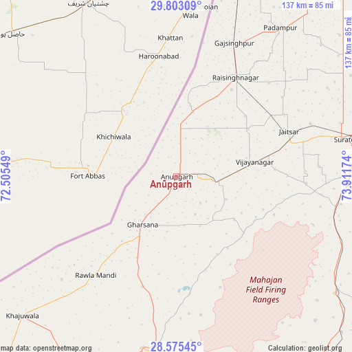
Anūpgarh GPS coordinates[2]
29° 11' 27.996" North, 73° 12' 30.996" East
| Map corner | latitude | longitude |
|---|---|---|
| Upper-left | 29.80309°, | 72.50549° |
| Center: | 29.19111°, | 73.20861° |
| Lower-right: | 28.57545°, | 73.91174° |
| Map W x H: | 136.5×136.5 km | = 84.8×84.8mi |
| max Lat: | 34.9274° ⇑10.3% North |
| Anūpgarh: | 29.19111° |
| min Lat: | ⇓89.7% South 8.09008° |
| min Long | Anūpgarh | max Long |
| 68.82655° | 73.20861° | 96.81° |
| W 6.3%⇐ | ⇒93.7% E |
Elevation
Elevation of Anūpgarh is 156 m = 512 ft, and this is 139.6 m = 458 ft below average elevation for this country.
| Max E: |
3681 m = 12077 ft | 58.4% |
| Avg. | 295.6 m = 970 ft | |
| Anūpgarh | 156 m = 512 ft | |
Min E: |
1 m = 3 ft | 41.6% |
See also: India elevation on elevation.city.
Geographical zone
Anūpgarh is located in North temperate zone (between Tropic of Cancer and the Arctic Circle). Distance of this Northern Tropic circle is 639.8 km =397.6 mi to South.| Distance of | km | miles | from Anūpgarh |
|---|---|---|---|
| North Pole | 6761.3 | 4201.3 | to North |
| Arctic Circle | 4155.4 | 2582 | to North |
| Tropic Cancer | 639.8 | 397.6 | to South |
| Equator | 3245.7 | 2016.8 | to South |


Nearby cities:
15 places around Anūpgarh: (largest is in red/bold)
• Abohar
142.6 km =88.6 mi,  41°
41°
• Bhādāsar
143.5 km =89.2 mi,  132°
132°
• Bīkaner
130.9 km =81.3 mi,  175°
175°
• Ellenabad
143.8 km =89.4 mi,  78°
78°
• Gangānagar
103.6 km =64.4 mi, 38°
• Hanumāngarh
117 km =72.7 mi,  68°
68°
• Karanpur
76 km =47.2 mi,  18°
18°
• Napāsar
141 km =87.6 mi,  165°
165°
• Padampur
70.3 km =43.7 mi, 35°
• Pilibangan
91.2 km =56.7 mi, 71°
• Rāisinghnagar
44.9 km =27.9 mi,  31°
31°
• Rāwatsār
116.2 km =72.2 mi,  85°
85°
• Sangariā
139.3 km =86.6 mi,  60°
60°
• Sri Dūngargarh
144.6 km =89.9 mi,  147°
147°
• Sūratgarh
68.6 km =42.6 mi, 77°
Sources, notices
• [Note1] Compared only with cities in India existing in our database
• [Src1] Map data: © OpenStreetMap contributors (CC-BY-SA)
• [Src2] Other city data from geonames.org with taken over terms of usage.
• [Src3] Geographical zone / Annual Mean Temperature by Robert A. Rohde @ Wikipedia
