Pratāpgarh geodata
Pratāpgarh (Uttar Pradesh) is a populated place; located in India in Asia/Kolkata (GMT+5.5) time zone. With population of 13,672 people, there are 2593 cities with bigger population in this country. Compared to other cities in India, 69.6% of cities are located further ↓South; 76.4% of cities are located further ←West and 68.2% of cities have higher elevation than Pratāpgarh. Note1


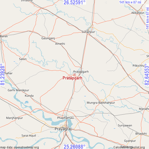
Pratāpgarh GPS coordinates[2]
25° 53' 42.324" North, 81° 56' 32.64" East
| Map corner | latitude | longitude |
|---|---|---|
| Upper-left | 26.52591°, | 81.23928° |
| Center: | 25.89509°, | 81.9424° |
| Lower-right: | 25.26088°, | 82.64553° |
| Map W x H: | 140.7×140.7 km | = 87.4×87.4mi |
| max Lat: | 34.9274° ⇑30.4% North |
| Pratāpgarh: | 25.89509° |
| min Lat: | ⇓69.6% South 8.09008° |
| min Long | Pratāpgarh | max Long |
| 68.82655° | 81.9424° | 96.81° |
| W 76.4%⇐ | ⇒23.6% E |
Elevation
Elevation of Pratāpgarh is 101 m = 331 ft, and this is 194.6 m = 638 ft below average elevation for this country.
| Max E: |
3681 m = 12077 ft | 68.2% |
| Avg. | 295.6 m = 970 ft | |
| Pratāpgarh | 101 m = 331 ft | |
Min E: |
1 m = 3 ft | 31.8% |
See also: India elevation on elevation.city.
Geographical zone
Pratāpgarh is located in North temperate zone (between Tropic of Cancer and the Arctic Circle). Distance of this Northern Tropic circle is 273.3 km =169.8 mi to South.| Distance of | km | miles | from Pratāpgarh |
|---|---|---|---|
| North Pole | 7127.8 | 4429 | to North |
| Arctic Circle | 4521.9 | 2809.8 | to North |
| Tropic Cancer | 273.3 | 169.8 | to South |
| Equator | 2879.3 | 1789.1 | to South |


Nearby cities:
15 places around Pratāpgarh: (largest is in red/bold)
• Allahābād
51 km =31.7 mi,  191°
191°
• Amethī
32.2 km =20 mi,  334°
334°
• Antu
18.4 km =11.4 mi,  347°
347°
• Bela
6.1 km =3.8 mi,  62°
62°
• Jhūsi
51 km =31.7 mi,  184°
184°
• Kunda
47.2 km =29.3 mi,  245°
245°
• Kādīpur
52.4 km =32.6 mi,  54°
54°
• Lālganj
24.1 km =15 mi,  279°
279°
• Machhlīshahr
52.4 km =32.6 mi,  116°
116°
• Mau Aimma
22.3 km =13.9 mi, 184°
• Parshādepur
49.2 km =30.6 mi,  293°
293°
• Patti
26 km =16.2 mi,  83°
83°
• Phulpur
41.2 km =25.6 mi,  159°
159°
• Salon
51 km =31.7 mi, 286°
• Sultānpur
42.4 km =26.3 mi,  17°
17°
Sources, notices
• [Note1] Compared only with cities in India existing in our database
• [Src1] Map data: © OpenStreetMap contributors (CC-BY-SA)
• [Src2] Other city data from geonames.org with taken over terms of usage.
• [Src3] Geographical zone / Annual Mean Temperature by Robert A. Rohde @ Wikipedia
