Parshādepur geodata
Parshādepur (Uttar Pradesh) is a populated place; located in India in Asia/Kolkata (GMT+5.5) time zone. With population of 10,690 people, there are 2870 cities with bigger population in this country. Compared to other cities in India, 70.9% of cities are located further ↓South; 74.6% of cities are located further ←West and 66.2% of cities have higher elevation than Parshādepur. Note1


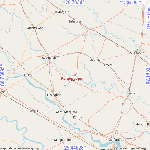
Parshādepur GPS coordinates[2]
26° 4' 24.744" North, 81° 29' 31.452" East
| Map corner | latitude | longitude |
|---|---|---|
| Upper-left | 26.7034°, | 80.78895° |
| Center: | 26.07354°, | 81.49207° |
| Lower-right: | 25.44028°, | 82.1952° |
| Map W x H: | 140.4×140.4 km | = 87.2×87.2mi |
| max Lat: | 34.9274° ⇑29.1% North |
| Parshādepur: | 26.07354° |
| min Lat: | ⇓70.9% South 8.09008° |
| min Long | Parshādepur | max Long |
| 68.82655° | 81.49207° | 96.81° |
| W 74.6%⇐ | ⇒25.4% E |
Elevation
Elevation of Parshādepur is 112 m = 367 ft, and this is 183.6 m = 602 ft below average elevation for this country.
| Max E: |
3681 m = 12077 ft | 66.2% |
| Avg. | 295.6 m = 970 ft | |
| Parshādepur | 112 m = 367 ft | |
Min E: |
1 m = 3 ft | 33.8% |
See also: India elevation on elevation.city.
Geographical zone
Parshādepur is located in North temperate zone (between Tropic of Cancer and the Arctic Circle). Distance of this Northern Tropic circle is 293.2 km =182.2 mi to South.| Distance of | km | miles | from Parshādepur |
|---|---|---|---|
| North Pole | 7108 | 4416.7 | to North |
| Arctic Circle | 4502.1 | 2797.5 | to North |
| Tropic Cancer | 293.2 | 182.2 | to South |
| Equator | 2899.1 | 1801.4 | to South |


Nearby cities:
15 places around Parshādepur: (largest is in red/bold)
• Amethī
32.6 km =20.3 mi,  73°
73°
• Antu
41.1 km =25.5 mi,  92°
92°
• Bela
53.2 km =33.1 mi,  108°
108°
• Bharwāri
57 km =35.4 mi,  180°
180°
• Dalmau
46.2 km =28.7 mi,  268°
268°
• Jais
22 km =13.7 mi,  14°
14°
• Khāga
51.3 km =31.9 mi,  229°
229°
• Kunda
39.7 km =24.7 mi, 176°
• Lālganj
26.5 km =16.5 mi,  126°
126°
• Mahārājganj
40.5 km =25.2 mi,  327°
327°
• Musāfir-Khāna
45.5 km =28.3 mi,  41°
41°
• Pratāpgarh
49.2 km =30.6 mi, 113°
• Raebareli
31.2 km =19.4 mi,  304°
304°
• Salon
6.3 km =3.9 mi,  217°
217°
• Sirāthu
50.9 km =31.6 mi,  199°
199°
Sources, notices
• [Note1] Compared only with cities in India existing in our database
• [Src1] Map data: © OpenStreetMap contributors (CC-BY-SA)
• [Src2] Other city data from geonames.org with taken over terms of usage.
• [Src3] Geographical zone / Annual Mean Temperature by Robert A. Rohde @ Wikipedia
