Jais geodata
Jais (Uttar Pradesh) is a populated place; located in India in Asia/Kolkata (GMT+5.5) time zone. With population of 25,726 people, there are 1655 cities with bigger population in this country. Compared to other cities in India, 72.6% of cities are located further ↓South; 75% of cities are located further ←West and 64.4% of cities have higher elevation than Jais. Note1


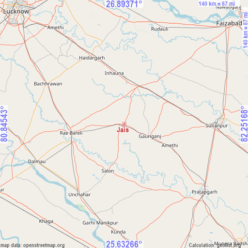
Jais GPS coordinates[2]
26° 15' 53.64" North, 81° 32' 54.78" East
| Map corner | latitude | longitude |
|---|---|---|
| Upper-left | 26.89371°, | 80.84543° |
| Center: | 26.2649°, | 81.54855° |
| Lower-right: | 25.63266°, | 82.25168° |
| Map W x H: | 140.2×140.2 km | = 87.1×87.1mi |
| max Lat: | 34.9274° ⇑27.4% North |
| Jais: | 26.2649° |
| min Lat: | ⇓72.6% South 8.09008° |
| min Long | Jais | max Long |
| 68.82655° | 81.54855° | 96.81° |
| W 75%⇐ | ⇒25% E |
Elevation
Elevation of Jais is 124 m = 407 ft, and this is 171.6 m = 563 ft below average elevation for this country.
| Max E: |
3681 m = 12077 ft | 64.4% |
| Avg. | 295.6 m = 970 ft | |
| Jais | 124 m = 407 ft | |
Min E: |
1 m = 3 ft | 35.6% |
See also: India elevation on elevation.city.
Geographical zone
Jais is located in North temperate zone (between Tropic of Cancer and the Arctic Circle). Distance of this Northern Tropic circle is 314.5 km =195.4 mi to South.| Distance of | km | miles | from Jais |
|---|---|---|---|
| North Pole | 7086.7 | 4403.5 | to North |
| Arctic Circle | 4480.8 | 2784.2 | to North |
| Tropic Cancer | 314.5 | 195.4 | to South |
| Equator | 2920.4 | 1814.7 | to South |


Nearby cities:
15 places around Jais: (largest is in red/bold)
• Amethī
28.3 km =17.6 mi,  115°
115°
• Antu
42.3 km =26.3 mi, 123°
• Bachhrāwān
48.8 km =30.3 mi,  297°
297°
• Bela
58.9 km =36.6 mi,  130°
130°
• Dalmau
56.3 km =35 mi,  246°
246°
• Kunda
61 km =37.9 mi,  183°
183°
• Lālganj
40.2 km =25 mi,  157°
157°
• Mahārājganj
30.2 km =18.8 mi, 295°
• Musāfir-Khāna
27.7 km =17.2 mi,  62°
62°
• Nagrām
56.6 km =35.2 mi,  314°
314°
• Parshādepur
22 km =13.7 mi,  194°
194°
• Pratāpgarh
56.9 km =35.4 mi,  136°
136°
• Raebareli
31.7 km =19.7 mi,  263°
263°
• Salon
27.9 km =17.3 mi,  199°
199°
• Sultānpur
52.3 km =32.5 mi,  90°
90°
Sources, notices
• [Note1] Compared only with cities in India existing in our database
• [Src1] Map data: © OpenStreetMap contributors (CC-BY-SA)
• [Src2] Other city data from geonames.org with taken over terms of usage.
• [Src3] Geographical zone / Annual Mean Temperature by Robert A. Rohde @ Wikipedia
