Fyzābād geodata
Fyzābād (Uttar Pradesh) is a populated place; located in India in Asia/Kolkata (GMT+5.5) time zone. With population of 153,047 people, there are 286 cities with bigger population in this country. Compared to other cities in India, 76.7% of cities are located further ↓South; 77% of cities are located further ←West and 67.2% of cities have higher elevation than Fyzābād. Note1


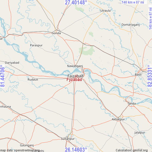
Fyzābād GPS coordinates[2]
26° 46' 31.764" North, 82° 9' 0.648" East
| Map corner | latitude | longitude |
|---|---|---|
| Upper-left | 27.40148°, | 81.44706° |
| Center: | 26.77549°, | 82.15018° |
| Lower-right: | 26.14603°, | 82.85331° |
| Map W x H: | 139.6×139.6 km | = 86.7×86.7mi |
| max Lat: | 34.9274° ⇑23.3% North |
| Fyzābād: | 26.77549° |
| min Lat: | ⇓76.7% South 8.09008° |
| min Long | Fyzābād | max Long |
| 68.82655° | 82.15018° | 96.81° |
| W 77%⇐ | ⇒23% E |
Elevation
Elevation of Fyzābād is 106 m = 348 ft, and this is 189.6 m = 622 ft below average elevation for this country.
| Max E: |
3681 m = 12077 ft | 67.2% |
| Avg. | 295.6 m = 970 ft | |
| Fyzābād | 106 m = 348 ft | |
Min E: |
1 m = 3 ft | 32.8% |
See also: Fyzābād elevation on elevation.city.
Geographical zone
Fyzābād is located in North temperate zone (between Tropic of Cancer and the Arctic Circle). Distance of this Northern Tropic circle is 371.2 km =230.7 mi to South.| Distance of | km | miles | from Fyzābād |
|---|---|---|---|
| North Pole | 7029.9 | 4368.2 | to North |
| Arctic Circle | 4424 | 2748.9 | to North |
| Tropic Cancer | 371.2 | 230.7 | to South |
| Equator | 2977.2 | 1849.9 | to South |


Nearby cities:
15 places around Fyzābād: (largest is in red/bold)
• Ajodhya
6 km =3.7 mi,  64°
64°
• Akbarpur
54.2 km =33.7 mi,  135°
135°
• Bastī
56.2 km =34.9 mi,  88°
88°
• Bīkāpur
20.1 km =12.5 mi,  184°
184°
• Colonelganj
60 km =37.3 mi,  311°
311°
• Dostpur
64.2 km =39.9 mi,  150°
150°
• Gondā City
44.2 km =27.5 mi,  333°
333°
• Goshāinganj
32.3 km =20.1 mi,  134°
134°
• Haraiya
31.3 km =19.4 mi, 86°
• Mankāpur
31.7 km =19.7 mi,  14°
14°
• Musāfir-Khāna
56.5 km =35.1 mi,  218°
218°
• Nawābganj
9.9 km =6.2 mi,  354°
354°
• Sultānpur
58.1 km =36.1 mi,  187°
187°
• Tikaitnagar
61 km =37.9 mi,  288°
288°
• Tāndā
56.4 km =35 mi,  116°
116°
Sources, notices
• [Note1] Compared only with cities in India existing in our database
• [Src1] Map data: © OpenStreetMap contributors (CC-BY-SA)
• [Src2] Other city data from geonames.org with taken over terms of usage.
• [Src3] Geographical zone / Annual Mean Temperature by Robert A. Rohde @ Wikipedia
