Buldāna geodata
Buldāna (Maharashtra) is a populated place; located in India in Asia/Kolkata (GMT+5.5) time zone. With population of 66,991 people, there are 647 cities with bigger population in this country. Compared to other cities in India, 63.6% of cities are located further ↑North; 71.9% of cities are located further →East and 91% of cities have lower elevation than Buldāna. Note1


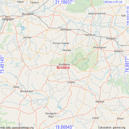
Buldāna GPS coordinates[2]
20° 31' 45.588" North, 76° 11' 4.452" East
| Map corner | latitude | longitude |
|---|---|---|
| Upper-left | 21.18637°, | 75.48145° |
| Center: | 20.52933°, | 76.18457° |
| Lower-right: | 19.86945°, | 76.8877° |
| Map W x H: | 146.4×146.4 km | = 91×91mi |
| max Lat: | 34.9274° ⇑63.6% North |
| Buldāna: | 20.52933° |
| min Lat: | ⇓36.4% South 8.09008° |
| min Long | Buldāna | max Long |
| 68.82655° | 76.18457° | 96.81° |
| W 28.1%⇐ | ⇒71.9% E |
Elevation
Elevation of Buldāna is 654 m = 2146 ft, and this is 358.4 m = 1176 ft above average elevation for this country.
| Max E: |
3681 m = 12077 ft | 9% |
| Buldāna | 654 m 2146 ft | |
| Avg. | 295.6 m = 970 ft | |
Min E: |
1 m = 3 ft | 91% |
See also: Buldāna elevation on elevation.city.
Geographical zone
Buldāna is located in North Torrid zone (between Equator and Tropic of Cancer). Distance of this Northern Tropic circle is 323.3 km =200.9 mi to North.| Distance of | km | miles | from Buldāna |
|---|---|---|---|
| North Pole | 7724.4 | 4799.7 | to North |
| Arctic Circle | 5118.5 | 3180.5 | to North |
| Tropic Cancer | 323.3 | 200.9 | to North |
| Equator | 2282.6 | 1418.3 | to South |


Nearby cities:
15 places around Buldāna: (largest is in red/bold)
• Bhusāval
70.7 km =43.9 mi,  324°
324°
• Bālāpur
63.2 km =39.3 mi,  76°
76°
• Chikhli
21.3 km =13.2 mi,  159°
159°
• Deūlgaon Rāja
58.9 km =36.6 mi,  195°
195°
• Jalgaon Jamod
68.6 km =42.6 mi,  32°
32°
• Khāmgaon
44.6 km =27.7 mi,  63°
63°
• Lonār
69.9 km =43.4 mi,  149°
149°
• Malkāpur
39.6 km =24.6 mi,  2°
2°
• Mehekar
58.1 km =36.1 mi,  136°
136°
• Nāndūra Buzurg
44.3 km =27.5 mi,  40°
40°
• Shegaon
61.1 km =38 mi, 61°
• Sillod
60.9 km =37.8 mi,  245°
245°
• Soygaon
59.5 km =37 mi,  277°
277°
• Sāvda
75.6 km =47 mi,  336°
336°
• Varangaon
61.3 km =38.1 mi,  332°
332°
Sources, notices
• [Note1] Compared only with cities in India existing in our database
• [Src1] Map data: © OpenStreetMap contributors (CC-BY-SA)
• [Src2] Other city data from geonames.org with taken over terms of usage.
• [Src3] Geographical zone / Annual Mean Temperature by Robert A. Rohde @ Wikipedia
