Sillod geodata
Sillod (Maharashtra) is a populated place; located in India in Asia/Kolkata (GMT+5.5) time zone. With population of 51,042 people, there are 871 cities with bigger population in this country. Compared to other cities in India, 64.2% of cities are located further ↑North; 77% of cities are located further →East and 89.1% of cities have lower elevation than Sillod. Note1


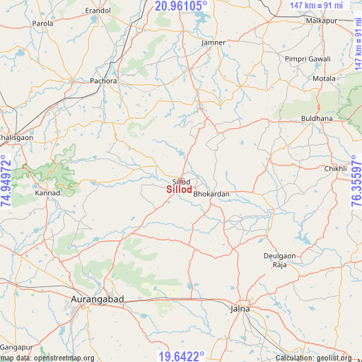
Sillod GPS coordinates[2]
20° 18' 10.908" North, 75° 39' 10.224" East
| Map corner | latitude | longitude |
|---|---|---|
| Upper-left | 20.96105°, | 74.94972° |
| Center: | 20.30303°, | 75.65284° |
| Lower-right: | 19.6422°, | 76.35597° |
| Map W x H: | 146.6×146.6 km | = 91.1×91.1mi |
| max Lat: | 34.9274° ⇑64.2% North |
| Sillod: | 20.30303° |
| min Lat: | ⇓35.8% South 8.09008° |
| min Long | Sillod | max Long |
| 68.82655° | 75.65284° | 96.81° |
| W 23%⇐ | ⇒77% E |
Elevation
Elevation of Sillod is 616 m = 2021 ft, and this is 320.4 m = 1051 ft above average elevation for this country.
| Max E: |
3681 m = 12077 ft | 10.9% |
| Sillod | 616 m 2021 ft | |
| Avg. | 295.6 m = 970 ft | |
Min E: |
1 m = 3 ft | 89.1% |
See also: Sillod elevation on elevation.city.
Geographical zone
Sillod is located in North Torrid zone (between Equator and Tropic of Cancer). Distance of this Northern Tropic circle is 348.4 km =216.5 mi to North.| Distance of | km | miles | from Sillod |
|---|---|---|---|
| North Pole | 7749.6 | 4815.4 | to North |
| Arctic Circle | 5143.7 | 3196.1 | to North |
| Tropic Cancer | 348.4 | 216.5 | to North |
| Equator | 2257.5 | 1402.7 | to South |


Nearby cities:
15 places around Sillod: (largest is in red/bold)
• Ambad
78 km =48.5 mi,  169°
169°
• Aurangabad
57.4 km =35.7 mi,  214°
214°
• Buldāna
60.9 km =37.8 mi,  65°
65°
• Chikhli
63.3 km =39.3 mi,  85°
85°
• Chālisgaon
68.6 km =42.6 mi,  284°
284°
• Daulatābād
60.8 km =37.8 mi,  227°
227°
• Deūlgaon Rāja
51.2 km =31.8 mi,  128°
128°
• Ellora
59.9 km =37.2 mi,  238°
238°
• Erandol
76.8 km =47.7 mi,  333°
333°
• Jālna
56.9 km =35.4 mi,  154°
154°
• Kannad
54 km =33.6 mi,  264°
264°
• Khuldābād
58.3 km =36.2 mi, 235°
• Pāchora
51.1 km =31.8 mi,  322°
322°
• Pīpri
57.9 km =36 mi,  192°
192°
• Soygaon
32.8 km =20.4 mi,  353°
353°
Sources, notices
• [Note1] Compared only with cities in India existing in our database
• [Src1] Map data: © OpenStreetMap contributors (CC-BY-SA)
• [Src2] Other city data from geonames.org with taken over terms of usage.
• [Src3] Geographical zone / Annual Mean Temperature by Robert A. Rohde @ Wikipedia
