Malkāpur geodata
Malkāpur (Maharashtra) is a populated place; located in India in Asia/Kolkata (GMT+5.5) time zone. With population of 64,812 people, there are 675 cities with bigger population in this country. Compared to other cities in India, 62.1% of cities are located further ↑North; 71.7% of cities are located further →East and 60.3% of cities have lower elevation than Malkāpur. Note1


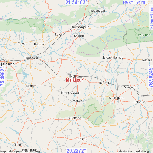
Malkāpur GPS coordinates[2]
20° 53' 7.98" North, 76° 11' 57.552" East
| Map corner | latitude | longitude |
|---|---|---|
| Upper-left | 21.54103°, | 75.4962° |
| Center: | 20.88555°, | 76.19932° |
| Lower-right: | 20.2272°, | 76.90245° |
| Map W x H: | 146.1×146.1 km | = 90.8×90.8mi |
| max Lat: | 34.9274° ⇑62.1% North |
| Malkāpur: | 20.88555° |
| min Lat: | ⇓37.9% South 8.09008° |
| min Long | Malkāpur | max Long |
| 68.82655° | 76.19932° | 96.81° |
| W 28.3%⇐ | ⇒71.7% E |
Elevation
Elevation of Malkāpur is 253 m = 830 ft, and this is 42.6 m = 140 ft below average elevation for this country.
| Max E: |
3681 m = 12077 ft | 39.7% |
| Avg. | 295.6 m = 970 ft | |
| Malkāpur | 253 m = 830 ft | |
Min E: |
1 m = 3 ft | 60.3% |
See also: Malkāpur elevation on elevation.city.
Geographical zone
Malkāpur is located in North Torrid zone (between Equator and Tropic of Cancer). Distance of this Northern Tropic circle is 283.7 km =176.3 mi to North.| Distance of | km | miles | from Malkāpur |
|---|---|---|---|
| North Pole | 7684.8 | 4775.1 | to North |
| Arctic Circle | 5078.9 | 3155.9 | to North |
| Tropic Cancer | 283.7 | 176.3 | to North |
| Equator | 2322.3 | 1443 | to South |


Nearby cities:
15 places around Malkāpur: (largest is in red/bold)
• Bhusāval
46.5 km =28.9 mi,  292°
292°
• Buldāna
39.6 km =24.6 mi,  182°
182°
• Burhānpur
47.2 km =29.3 mi,  3°
3°
• Bālāpur
64.5 km =40.1 mi,  112°
112°
• Chikhli
59.8 km =37.2 mi,  174°
174°
• Faizpur
47.2 km =29.3 mi,  311°
311°
• Jalgaon Jamod
39.4 km =24.5 mi,  62°
62°
• Khāmgaon
43.2 km =26.8 mi,  117°
117°
• Nāndūra Buzurg
27.6 km =17.1 mi,  101°
101°
• Rāver
43.7 km =27.2 mi,  337°
337°
• Shegaon
53 km =32.9 mi, 101°
• Shāhpur
39.2 km =24.4 mi, 3°
• Sāvda
43.6 km =27.1 mi, 312°
• Varangaon
33.4 km =20.8 mi,  296°
296°
• Yāval
60.8 km =37.8 mi, 301°
Sources, notices
• [Note1] Compared only with cities in India existing in our database
• [Src1] Map data: © OpenStreetMap contributors (CC-BY-SA)
• [Src2] Other city data from geonames.org with taken over terms of usage.
• [Src3] Geographical zone / Annual Mean Temperature by Robert A. Rohde @ Wikipedia
