Faridabad geodata
Faridabad (Haryana) is a populated place; located in India in Asia/Kolkata (GMT+5.5) time zone. With population of 1,220,229 people, there are 29 cities with bigger population in this country. Compared to other cities in India, 86.4% of cities are located further ↓South; 59.5% of cities are located further →East and 51.3% of cities have lower elevation than Faridabad. Note1


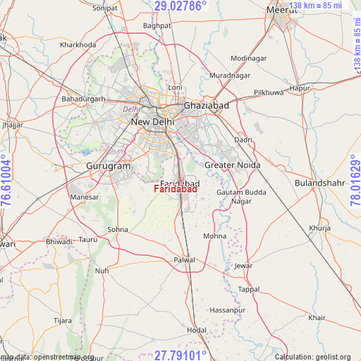
Faridabad GPS coordinates[2]
28° 24' 40.464" North, 77° 18' 47.376" East
| Map corner | latitude | longitude |
|---|---|---|
| Upper-left | 29.02786°, | 76.61004° |
| Center: | 28.41124°, | 77.31316° |
| Lower-right: | 27.79101°, | 78.01629° |
| Map W x H: | 137.5×137.5 km | = 85.4×85.4mi |
| max Lat: | 34.9274° ⇑13.6% North |
| Faridabad: | 28.41124° |
| min Lat: | ⇓86.4% South 8.09008° |
| min Long | Faridabad | max Long |
| 68.82655° | 77.31316° | 96.81° |
| W 40.5%⇐ | ⇒59.5% E |
Elevation
Elevation of Faridabad is 209 m = 686 ft, and this is 86.6 m = 284 ft below average elevation for this country.
| Max E: |
3681 m = 12077 ft | 48.7% |
| Avg. | 295.6 m = 970 ft | |
| Faridabad | 209 m = 686 ft | |
Min E: |
1 m = 3 ft | 51.3% |
See also: Faridabad elevation on elevation.city.
Geographical zone
Faridabad is located in North temperate zone (between Tropic of Cancer and the Arctic Circle). Distance of this Northern Tropic circle is 553.1 km =343.7 mi to South.| Distance of | km | miles | from Faridabad |
|---|---|---|---|
| North Pole | 6848 | 4255.1 | to North |
| Arctic Circle | 4242.1 | 2635.9 | to North |
| Tropic Cancer | 553.1 | 343.7 | to South |
| Equator | 3159 | 1962.9 | to South |


Nearby cities:
15 places around Faridabad: (largest is in red/bold)
• Bīlāspur
30.5 km =19 mi,  94°
94°
• Dankaur
24.6 km =15.3 mi,  105°
105°
• Defence Colony
19.5 km =12.1 mi,  336°
336°
• Delhi
27.9 km =17.3 mi, 343°
• Deoli
12.9 km =8 mi,  321°
321°
• Dādri
28.3 km =17.6 mi,  56°
56°
• Greater Noida
23.7 km =14.7 mi,  66°
66°
• Gurgaon
28.6 km =17.8 mi,  280°
280°
• Karol Bāgh
29.3 km =18.2 mi, 335°
• New Delhi
26.4 km =16.4 mi, 340°
• Noida
18.8 km =11.7 mi,  5°
5°
• Palwal
29.7 km =18.5 mi,  177°
177°
• Sector
17.8 km =11.1 mi,  4°
4°
• Shahdara
27.2 km =16.9 mi, 321°
• Sohna
30.3 km =18.8 mi,  233°
233°
Sources, notices
• [Note1] Compared only with cities in India existing in our database
• [Src1] Map data: © OpenStreetMap contributors (CC-BY-SA)
• [Src2] Other city data from geonames.org with taken over terms of usage.
• [Src3] Geographical zone / Annual Mean Temperature by Robert A. Rohde @ Wikipedia
