Bhawāniganj geodata
Bhawāniganj (Madhya Pradesh) is a populated place; located in India in Asia/Kolkata (GMT+5.5) time zone. With population of 38,030 people, there are 1155 cities with bigger population in this country. Compared to other cities in India, 60.1% of cities are located further ↓South; 75.4% of cities are located further →East and 74.6% of cities have lower elevation than Bhawāniganj. Note1


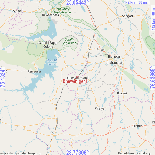
Bhawāniganj GPS coordinates[2]
24° 24' 56.952" North, 75° 50' 7.872" East
| Map corner | latitude | longitude |
|---|---|---|
| Upper-left | 25.05443°, | 75.1324° |
| Center: | 24.41582°, | 75.83552° |
| Lower-right: | 23.77396°, | 76.53865° |
| Map W x H: | 142.4×142.4 km | = 88.5×88.5mi |
| max Lat: | 34.9274° ⇑39.9% North |
| Bhawāniganj: | 24.41582° |
| min Lat: | ⇓60.1% South 8.09008° |
| min Long | Bhawāniganj | max Long |
| 68.82655° | 75.83552° | 96.81° |
| W 24.6%⇐ | ⇒75.4% E |
Elevation
Elevation of Bhawāniganj is 381 m = 1250 ft, and this is 85.4 m = 280 ft above average elevation for this country.
| Max E: |
3681 m = 12077 ft | 25.4% |
| Bhawāniganj | 381 m 1250 ft | |
| Avg. | 295.6 m = 970 ft | |
Min E: |
1 m = 3 ft | 74.6% |
See also: India elevation on elevation.city.
Geographical zone
Bhawāniganj is located in North temperate zone (between Tropic of Cancer and the Arctic Circle). Distance of this Northern Tropic circle is 108.9 km =67.7 mi to South.| Distance of | km | miles | from Bhawāniganj |
|---|---|---|---|
| North Pole | 7292.3 | 4531.2 | to North |
| Arctic Circle | 4686.4 | 2912 | to North |
| Tropic Cancer | 108.9 | 67.7 | to South |
| Equator | 2714.8 | 1686.9 | to South |


Nearby cities:
15 places around Bhawāniganj: (largest is in red/bold)
• Bakāni
43.2 km =26.8 mi,  109°
109°
• Bhānpura
14 km =8.7 mi,  320°
320°
• Chechat
39.3 km =24.4 mi,  7°
7°
• Jhālrapātan
36.9 km =22.9 mi,  67°
67°
• Jhālāwār
38.9 km =24.2 mi,  58°
58°
• Māchalpur
58.4 km =36.3 mi,  123°
123°
• Pirāwa
34.9 km =21.7 mi,  146°
146°
• Rāmganj Mandi
27.9 km =17.3 mi,  23°
23°
• Rāmpura
40.4 km =25.1 mi,  278°
278°
• Rāwatbhāta
62.2 km =38.6 mi,  336°
336°
• Shāmgarh
32.2 km =20 mi,  218°
218°
• Suket
33 km =20.5 mi,  39°
39°
• Sunel
13.3 km =8.3 mi, 112°
• Susner
58.1 km =36.1 mi, 153°
• Udpura
38 km =23.6 mi, 21°
Sources, notices
• [Note1] Compared only with cities in India existing in our database
• [Src1] Map data: © OpenStreetMap contributors (CC-BY-SA)
• [Src2] Other city data from geonames.org with taken over terms of usage.
• [Src3] Geographical zone / Annual Mean Temperature by Robert A. Rohde @ Wikipedia
