Shāmgarh geodata
Shāmgarh (Madhya Pradesh) is a populated place; located in India in Asia/Kolkata (GMT+5.5) time zone. With population of 23,075 people, there are 1832 cities with bigger population in this country. Compared to other cities in India, 59% of cities are located further ↓South; 77.2% of cities are located further →East and 80.7% of cities have lower elevation than Shāmgarh. Note1


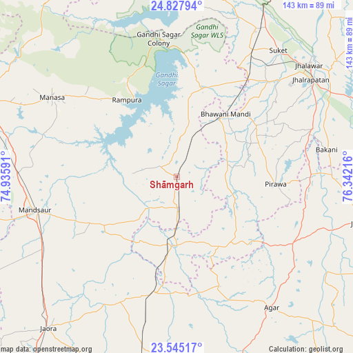
Shāmgarh GPS coordinates[2]
24° 11' 17.412" North, 75° 38' 20.508" East
| Map corner | latitude | longitude |
|---|---|---|
| Upper-left | 24.82794°, | 74.93591° |
| Center: | 24.18817°, | 75.63903° |
| Lower-right: | 23.54517°, | 76.34216° |
| Map W x H: | 142.6×142.6 km | = 88.6×88.6mi |
| max Lat: | 34.9274° ⇑41% North |
| Shāmgarh: | 24.18817° |
| min Lat: | ⇓59% South 8.09008° |
| min Long | Shāmgarh | max Long |
| 68.82655° | 75.63903° | 96.81° |
| W 22.8%⇐ | ⇒77.2% E |
Elevation
Elevation of Shāmgarh is 469 m = 1539 ft, and this is 173.4 m = 569 ft above average elevation for this country.
| Max E: |
3681 m = 12077 ft | 19.3% |
| Shāmgarh | 469 m 1539 ft | |
| Avg. | 295.6 m = 970 ft | |
Min E: |
1 m = 3 ft | 80.7% |
See also: India elevation on elevation.city.
Geographical zone
Shāmgarh is located in North temperate zone (between Tropic of Cancer and the Arctic Circle). Distance of this Northern Tropic circle is 83.6 km =51.9 mi to South.| Distance of | km | miles | from Shāmgarh |
|---|---|---|---|
| North Pole | 7317.6 | 4546.9 | to North |
| Arctic Circle | 4711.7 | 2927.7 | to North |
| Tropic Cancer | 83.6 | 51.9 | to South |
| Equator | 2689.5 | 1671.2 | to South |


Nearby cities:
15 places around Shāmgarh: (largest is in red/bold)
• Alot
48 km =29.8 mi,  190°
190°
• Bakāni
61.6 km =38.3 mi,  79°
79°
• Bhawāniganj
32.2 km =20 mi,  38°
38°
• Bhānpura
37.7 km =23.4 mi,  16°
16°
• Mandsaur
59.2 km =36.8 mi,  257°
257°
• Manāsa
59.9 km =37.2 mi,  302°
302°
• Nārāyangarh
60.4 km =37.5 mi,  278°
278°
• Pirāwa
39.6 km =24.6 mi,  95°
95°
• Rāmganj Mandi
59.5 km =37 mi,  31°
31°
• Rāmpura
37 km =23 mi,  326°
326°
• Suket
65.2 km =40.5 mi, 38°
• Sunel
38.1 km =23.7 mi,  57°
57°
• Susner
52.9 km =32.9 mi,  120°
120°
• Sītāmau
34.8 km =21.6 mi,  236°
236°
• Tāl
58.1 km =36.1 mi,  206°
206°
Sources, notices
• [Note1] Compared only with cities in India existing in our database
• [Src1] Map data: © OpenStreetMap contributors (CC-BY-SA)
• [Src2] Other city data from geonames.org with taken over terms of usage.
• [Src3] Geographical zone / Annual Mean Temperature by Robert A. Rohde @ Wikipedia
