Ārangaon geodata
Ārangaon (Maharashtra) is a populated place; located in India in Asia/Kolkata (GMT+5.5) time zone. With population of 29,591 people, there are 1469 cities with bigger population in this country. Compared to other cities in India, 68.5% of cities are located further ↑North; 85.2% of cities are located further →East and 91.6% of cities have lower elevation than Ārangaon. Note1


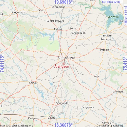
Ārangaon GPS coordinates[2]
19° 1' 36.516" North, 74° 42' 53.532" East
| Map corner | latitude | longitude |
|---|---|---|
| Upper-left | 19.69018°, | 74.01175° |
| Center: | 19.02681°, | 74.71487° |
| Lower-right: | 18.36078°, | 75.418° |
| Map W x H: | 147.8×147.8 km | = 91.8×91.8mi |
| max Lat: | 34.9274° ⇑68.5% North |
| Ārangaon: | 19.02681° |
| min Lat: | ⇓31.5% South 8.09008° |
| min Long | Ārangaon | max Long |
| 68.82655° | 74.71487° | 96.81° |
| W 14.8%⇐ | ⇒85.2% E |
Elevation
Elevation of Ārangaon is 672 m = 2205 ft, and this is 376.4 m = 1235 ft above average elevation for this country.
| Max E: |
3681 m = 12077 ft | 8.4% |
| Ārangaon | 672 m 2205 ft | |
| Avg. | 295.6 m = 970 ft | |
Min E: |
1 m = 3 ft | 91.6% |
See also: India elevation on elevation.city.
Geographical zone
Ārangaon is located in North Torrid zone (between Equator and Tropic of Cancer). Distance of this Northern Tropic circle is 490.3 km =304.7 mi to North.| Distance of | km | miles | from Ārangaon |
|---|---|---|---|
| North Pole | 7891.5 | 4903.5 | to North |
| Arctic Circle | 5285.6 | 3284.3 | to North |
| Tropic Cancer | 490.3 | 304.7 | to North |
| Equator | 2115.6 | 1314.6 | to South |


Nearby cities:
15 places around Ārangaon: (largest is in red/bold)
• Ahmadnagar
7.9 km =4.9 mi,  18°
18°
• Bhigvan
80.9 km =50.3 mi,  176°
176°
• Daund
64 km =39.8 mi,  192°
192°
• Gangāpur
80.7 km =50.1 mi, 22°
• Kalamb
79.8 km =49.6 mi,  271°
271°
• Karmāla
85.3 km =53 mi,  143°
143°
• Koregaon
81 km =50.3 mi,  238°
238°
• Manchar
81.1 km =50.4 mi, 268°
• Paithan
86.3 km =53.6 mi,  54°
54°
• Pāthardi
50.9 km =31.6 mi,  71°
71°
• Rāhuri
41 km =25.5 mi,  350°
350°
• Sangamner
80.1 km =49.8 mi,  318°
318°
• Shirdi
85.9 km =53.4 mi,  343°
343°
• Shrīgonda
45.8 km =28.5 mi, 182°
• Sirūr
42.1 km =26.2 mi, 238°
Sources, notices
• [Note1] Compared only with cities in India existing in our database
• [Src1] Map data: © OpenStreetMap contributors (CC-BY-SA)
• [Src2] Other city data from geonames.org with taken over terms of usage.
• [Src3] Geographical zone / Annual Mean Temperature by Robert A. Rohde @ Wikipedia
