Daund geodata
Daund (Maharashtra) is a populated place; located in India in Asia/Kolkata (GMT+5.5) time zone. With population of 45,440 people, there are 974 cities with bigger population in this country. Compared to other cities in India, 70.5% of cities are located further ↑North; 86.2% of cities are located further →East and 83.6% of cities have lower elevation than Daund. Note1


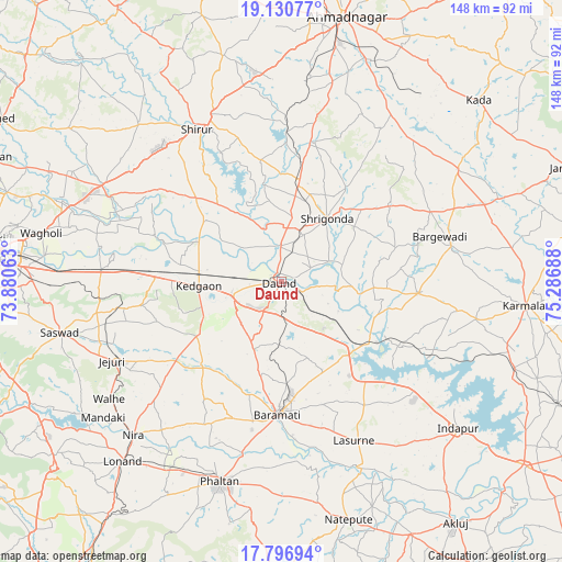
Daund GPS coordinates[2]
18° 27' 54.54" North, 74° 35' 1.5" East
| Map corner | latitude | longitude |
|---|---|---|
| Upper-left | 19.13077°, | 73.88063° |
| Center: | 18.46515°, | 74.58375° |
| Lower-right: | 17.79694°, | 75.28688° |
| Map W x H: | 148.3×148.3 km | = 92.1×92.1mi |
| max Lat: | 34.9274° ⇑70.5% North |
| Daund: | 18.46515° |
| min Lat: | ⇓29.5% South 8.09008° |
| min Long | Daund | max Long |
| 68.82655° | 74.58375° | 96.81° |
| W 13.8%⇐ | ⇒86.2% E |
Elevation
Elevation of Daund is 517 m = 1696 ft, and this is 221.4 m = 726 ft above average elevation for this country.
| Max E: |
3681 m = 12077 ft | 16.4% |
| Daund | 517 m 1696 ft | |
| Avg. | 295.6 m = 970 ft | |
Min E: |
1 m = 3 ft | 83.6% |
See also: Daund elevation on elevation.city.
Geographical zone
Daund is located in North Torrid zone (between Equator and Tropic of Cancer). Distance of this Northern Tropic circle is 552.8 km =343.5 mi to North.| Distance of | km | miles | from Daund |
|---|---|---|---|
| North Pole | 7953.9 | 4942.3 | to North |
| Arctic Circle | 5348 | 3323.1 | to North |
| Tropic Cancer | 552.8 | 343.5 | to North |
| Equator | 2053.1 | 1275.7 | to South |


Nearby cities:
15 places around Daund: (largest is in red/bold)
• Ahmadnagar
71.9 km =44.7 mi,  13°
13°
• Alandi
76 km =47.2 mi,  288°
288°
• Bhigvan
26.6 km =16.5 mi,  133°
133°
• Bārāmati
34.9 km =21.7 mi,  181°
181°
• Jejūri
49.4 km =30.7 mi,  244°
244°
• Kalas
39.2 km =24.4 mi,  146°
146°
• Karmāla
64.7 km =40.2 mi,  95°
95°
• Koregaon
58.8 km =36.5 mi, 289°
• Lohogaon
70.8 km =44 mi,  282°
282°
• Phaltan
55.1 km =34.2 mi,  196°
196°
• Shirwal
72.9 km =45.3 mi, 241°
• Shrīgonda
20.6 km =12.8 mi,  36°
36°
• Sirūr
45.9 km =28.5 mi,  331°
331°
• Sāsvad
59.9 km =37.2 mi,  256°
256°
• Ārangaon
64 km =39.8 mi, 12°
Sources, notices
• [Note1] Compared only with cities in India existing in our database
• [Src1] Map data: © OpenStreetMap contributors (CC-BY-SA)
• [Src2] Other city data from geonames.org with taken over terms of usage.
• [Src3] Geographical zone / Annual Mean Temperature by Robert A. Rohde @ Wikipedia
