Ahmadnagar geodata
Ahmadnagar (Maharashtra) is a populated place; located in India in Asia/Kolkata (GMT+5.5) time zone. With population of 367,140 people, there are 118 cities with bigger population in this country. Compared to other cities in India, 68.3% of cities are located further ↑North; 85% of cities are located further →East and 91.2% of cities have lower elevation than Ahmadnagar. Note1


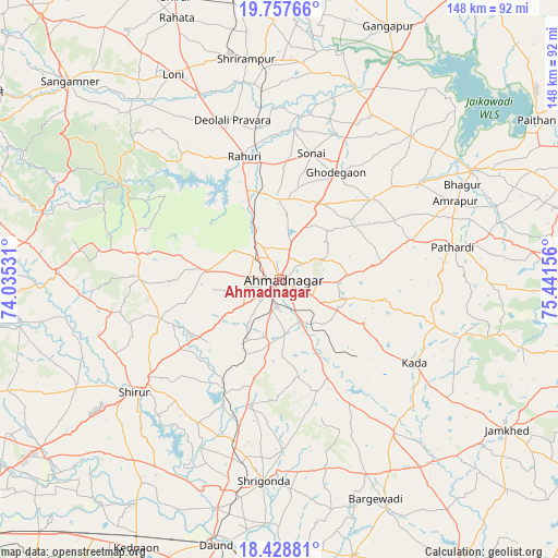
Ahmadnagar GPS coordinates[2]
19° 5' 40.452" North, 74° 44' 18.348" East
| Map corner | latitude | longitude |
|---|---|---|
| Upper-left | 19.75766°, | 74.03531° |
| Center: | 19.09457°, | 74.73843° |
| Lower-right: | 18.42881°, | 75.44156° |
| Map W x H: | 147.8×147.8 km | = 91.8×91.8mi |
| max Lat: | 34.9274° ⇑68.3% North |
| Ahmadnagar: | 19.09457° |
| min Lat: | ⇓31.7% South 8.09008° |
| min Long | Ahmadnagar | max Long |
| 68.82655° | 74.73843° | 96.81° |
| W 15%⇐ | ⇒85% E |
Elevation
Elevation of Ahmadnagar is 661 m = 2169 ft, and this is 365.4 m = 1199 ft above average elevation for this country.
| Max E: |
3681 m = 12077 ft | 8.8% |
| Ahmadnagar | 661 m 2169 ft | |
| Avg. | 295.6 m = 970 ft | |
Min E: |
1 m = 3 ft | 91.2% |
See also: Ahmadnagar elevation on elevation.city.
Geographical zone
Ahmadnagar is located in North Torrid zone (between Equator and Tropic of Cancer). Distance of this Northern Tropic circle is 482.8 km =300 mi to North.| Distance of | km | miles | from Ahmadnagar |
|---|---|---|---|
| North Pole | 7883.9 | 4898.8 | to North |
| Arctic Circle | 5278.1 | 3279.7 | to North |
| Tropic Cancer | 482.8 | 300 | to North |
| Equator | 2123.1 | 1319.2 | to South |


Nearby cities:
15 places around Ahmadnagar: (largest is in red/bold)
• Bhigvan
88.3 km =54.9 mi,  178°
178°
• Daund
71.9 km =44.7 mi,  193°
193°
• Gangāpur
72.8 km =45.2 mi,  23°
23°
• Kalamb
82.5 km =51.3 mi,  266°
266°
• Karmāla
90.2 km =56 mi,  147°
147°
• Koregaon
87.2 km =54.2 mi,  235°
235°
• Manchar
84.2 km =52.3 mi,  263°
263°
• Paithan
80 km =49.7 mi,  58°
58°
• Pāthardi
46.6 km =29 mi,  79°
79°
• Rāhuri
34.2 km =21.3 mi,  344°
344°
• Sangamner
76.3 km =47.4 mi,  313°
313°
• Shirdi
79.5 km =49.4 mi, 339°
• Shrīgonda
53.5 km =33.2 mi, 184°
• Sirūr
48.4 km =30.1 mi,  232°
232°
• Ārangaon
7.9 km =4.9 mi,  198°
198°
Sources, notices
• [Note1] Compared only with cities in India existing in our database
• [Src1] Map data: © OpenStreetMap contributors (CC-BY-SA)
• [Src2] Other city data from geonames.org with taken over terms of usage.
• [Src3] Geographical zone / Annual Mean Temperature by Robert A. Rohde @ Wikipedia
