Kichha geodata
Kichha (Uttarakhand) is a populated place; located in India in Asia/Kolkata (GMT+5.5) time zone. With population of 34,904 people, there are 1248 cities with bigger population in this country. Compared to other cities in India, 88.8% of cities are located further ↓South; 64% of cities are located further ←West and 51.1% of cities have lower elevation than Kichha. Note1


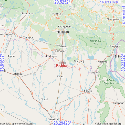
Kichha GPS coordinates[2]
28° 54' 41.544" North, 79° 31' 12.324" East
| Map corner | latitude | longitude |
|---|---|---|
| Upper-left | 29.5252°, | 78.81697° |
| Center: | 28.91154°, | 79.52009° |
| Lower-right: | 28.29423°, | 80.22322° |
| Map W x H: | 136.9×136.9 km | = 85.1×85.1mi |
| max Lat: | 34.9274° ⇑11.2% North |
| Kichha: | 28.91154° |
| min Lat: | ⇓88.8% South 8.09008° |
| min Long | Kichha | max Long |
| 68.82655° | 79.52009° | 96.81° |
| W 64%⇐ | ⇒36% E |
Elevation
Elevation of Kichha is 208 m = 682 ft, and this is 87.6 m = 287 ft below average elevation for this country.
| Max E: |
3681 m = 12077 ft | 48.9% |
| Avg. | 295.6 m = 970 ft | |
| Kichha | 208 m = 682 ft | |
Min E: |
1 m = 3 ft | 51.1% |
See also: India elevation on elevation.city.
Geographical zone
Kichha is located in North temperate zone (between Tropic of Cancer and the Arctic Circle). Distance of this Northern Tropic circle is 608.7 km =378.2 mi to South.| Distance of | km | miles | from Kichha |
|---|---|---|---|
| North Pole | 6792.4 | 4220.6 | to North |
| Arctic Circle | 4186.5 | 2601.4 | to North |
| Tropic Cancer | 608.7 | 378.2 | to South |
| Equator | 3214.7 | 1997.5 | to South |


Nearby cities:
15 places around Kichha: (largest is in red/bold)
• Baheri
15.4 km =9.6 mi,  188°
188°
• Bīlāspur
24.5 km =15.2 mi,  263°
263°
• Deoraniān
31.6 km =19.6 mi, 187°
• Haldwani
34.6 km =21.5 mi,  1°
1°
• Jahānābād
36.8 km =22.9 mi,  148°
148°
• Kemrī
32.8 km =20.4 mi,  249°
249°
• Khatīma
43.9 km =27.3 mi,  88°
88°
• Kālādhūngi
44.5 km =27.7 mi,  338°
338°
• Nawābganj
42.7 km =26.5 mi,  164°
164°
• Pīlibhīt
41.7 km =25.9 mi,  138°
138°
• Richha
24.1 km =15 mi,  179°
179°
• Shergarh
32.5 km =20.2 mi,  207°
207°
• Shāhi
44.8 km =27.8 mi, 206°
• Shīshgarh
28.5 km =17.7 mi,  224°
224°
• Sitārganj
18 km =11.2 mi,  83°
83°
Sources, notices
• [Note1] Compared only with cities in India existing in our database
• [Src1] Map data: © OpenStreetMap contributors (CC-BY-SA)
• [Src2] Other city data from geonames.org with taken over terms of usage.
• [Src3] Geographical zone / Annual Mean Temperature by Robert A. Rohde @ Wikipedia
