Channagiri geodata
Channagiri (Karnataka) is a populated place; located in India in Asia/Kolkata (GMT+5.5) time zone. With population of 20,376 people, there are 2012 cities with bigger population in this country. Compared to other cities in India, 83.3% of cities are located further ↑North; 74.3% of cities are located further →East and 92.3% of cities have lower elevation than Channagiri. Note1


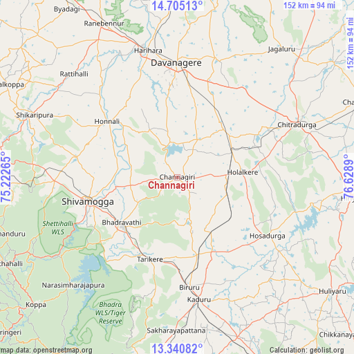
Channagiri GPS coordinates[2]
14° 1' 26.364" North, 75° 55' 32.772" East
| Map corner | latitude | longitude |
|---|---|---|
| Upper-left | 14.70513°, | 75.22265° |
| Center: | 14.02399°, | 75.92577° |
| Lower-right: | 13.34082°, | 76.6289° |
| Map W x H: | 151.7×151.7 km | = 94.3×94.3mi |
| max Lat: | 34.9274° ⇑83.3% North |
| Channagiri: | 14.02399° |
| min Lat: | ⇓16.7% South 8.09008° |
| min Long | Channagiri | max Long |
| 68.82655° | 75.92577° | 96.81° |
| W 25.7%⇐ | ⇒74.3% E |
Elevation
Elevation of Channagiri is 691 m = 2267 ft, and this is 395.4 m = 1297 ft above average elevation for this country.
| Max E: |
3681 m = 12077 ft | 7.7% |
| Channagiri | 691 m 2267 ft | |
| Avg. | 295.6 m = 970 ft | |
Min E: |
1 m = 3 ft | 92.3% |
See also: India elevation on elevation.city.
Geographical zone
Channagiri is located in North Torrid zone (between Equator and Tropic of Cancer). Distance of this Northern Tropic circle is 1046.6 km =650.3 mi to North.| Distance of | km | miles | from Channagiri |
|---|---|---|---|
| North Pole | 8447.7 | 5249.2 | to North |
| Arctic Circle | 5841.9 | 3630 | to North |
| Tropic Cancer | 1046.6 | 650.3 | to North |
| Equator | 1559.3 | 968.9 | to South |


Nearby cities:
15 places around Channagiri: (largest is in red/bold)
• Ajjampur
34.1 km =21.2 mi,  165°
165°
• Bhadrāvati
30.8 km =19.1 mi,  230°
230°
• Birūr
47.7 km =29.6 mi, 174°
• Chitradurga
55.7 km =34.6 mi,  66°
66°
• Davangere
49.3 km =30.6 mi,  0°
0°
• Harihar
55.8 km =34.7 mi,  346°
346°
• Holalkere
28 km =17.4 mi,  85°
85°
• Honnāli
38.6 km =24 mi,  308°
308°
• Hosdurga
46.2 km =28.7 mi,  123°
123°
• Kadūr
53.2 km =33.1 mi, 169°
• Kumsi
56.8 km =35.3 mi,  273°
273°
• Māyakonda
34 km =21.1 mi,  29°
29°
• Nyāmti
40.1 km =24.9 mi,  290°
290°
• Shimoga
40 km =24.9 mi,  255°
255°
• Tarikere
37 km =23 mi,  199°
199°
Sources, notices
• [Note1] Compared only with cities in India existing in our database
• [Src1] Map data: © OpenStreetMap contributors (CC-BY-SA)
• [Src2] Other city data from geonames.org with taken over terms of usage.
• [Src3] Geographical zone / Annual Mean Temperature by Robert A. Rohde @ Wikipedia
