Berasia geodata
Berasia (Madhya Pradesh) is a populated place; located in India in Asia/Kolkata (GMT+5.5) time zone. With population of 27,091 people, there are 1582 cities with bigger population in this country. Compared to other cities in India, 55.6% of cities are located further ↓South; 58% of cities are located further →East and 81.6% of cities have lower elevation than Berasia. Note1


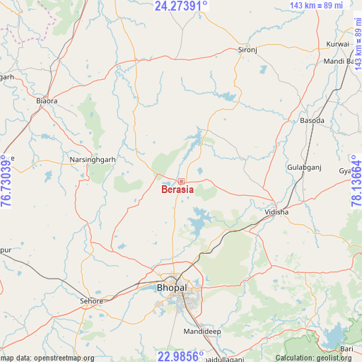
Berasia GPS coordinates[2]
23° 37' 52.824" North, 77° 26' 0.636" East
| Map corner | latitude | longitude |
|---|---|---|
| Upper-left | 24.27391°, | 76.73039° |
| Center: | 23.63134°, | 77.43351° |
| Lower-right: | 22.9856°, | 78.13664° |
| Map W x H: | 143.2×143.2 km | = 89×89mi |
| max Lat: | 34.9274° ⇑44.4% North |
| Berasia: | 23.63134° |
| min Lat: | ⇓55.6% South 8.09008° |
| min Long | Berasia | max Long |
| 68.82655° | 77.43351° | 96.81° |
| W 42%⇐ | ⇒58% E |
Elevation
Elevation of Berasia is 483 m = 1585 ft, and this is 187.4 m = 615 ft above average elevation for this country.
| Max E: |
3681 m = 12077 ft | 18.4% |
| Berasia | 483 m 1585 ft | |
| Avg. | 295.6 m = 970 ft | |
Min E: |
1 m = 3 ft | 81.6% |
See also: India elevation on elevation.city.
Geographical zone
Berasia is located in North temperate zone (between Tropic of Cancer and the Arctic Circle). Distance of this Northern Tropic circle is 21.6 km =13.4 mi to South.| Distance of | km | miles | from Berasia |
|---|---|---|---|
| North Pole | 7379.5 | 4585.4 | to North |
| Arctic Circle | 4773.6 | 2966.2 | to North |
| Tropic Cancer | 21.6 | 13.4 | to South |
| Equator | 2627.6 | 1632.7 | to South |


Nearby cities:
15 places around Berasia: (largest is in red/bold)
• Bhopal
42 km =26.1 mi,  184°
184°
• Biaora
62.2 km =38.6 mi,  301°
301°
• Bāsoda
56.7 km =35.2 mi,  64°
64°
• Chandpura
28.3 km =17.6 mi,  330°
330°
• Garha Brahman
27.5 km =17.1 mi,  343°
343°
• Khata Khedi
30.5 km =19 mi, 331°
• Leteri
47.7 km =29.6 mi,  356°
356°
• Mandideep
62 km =38.5 mi,  170°
170°
• Narsinghgarh
35.7 km =22.2 mi,  283°
283°
• Patalpani
24.7 km =15.3 mi, 340°
• Raisen
48.8 km =30.3 mi,  133°
133°
• Sehore
59.8 km =37.2 mi,  216°
216°
• Sironj
58.6 km =36.4 mi,  26°
26°
• Sānchi
34.9 km =21.7 mi,  117°
117°
• Vidisha
40.2 km =25 mi,  106°
106°
Sources, notices
• [Note1] Compared only with cities in India existing in our database
• [Src1] Map data: © OpenStreetMap contributors (CC-BY-SA)
• [Src2] Other city data from geonames.org with taken over terms of usage.
• [Src3] Geographical zone / Annual Mean Temperature by Robert A. Rohde @ Wikipedia
