Bhopal geodata
Bhopal (Madhya Pradesh) is a seat of a first-order administrative division; located in India in Asia/Kolkata (GMT+5.5) time zone. With population of 1,599,914 people, there are 16 cities with bigger population in this country. Compared to other cities in India, 53.3% of cities are located further ↓South; 58.3% of cities are located further →East and 83.8% of cities have lower elevation than Bhopal. Note1


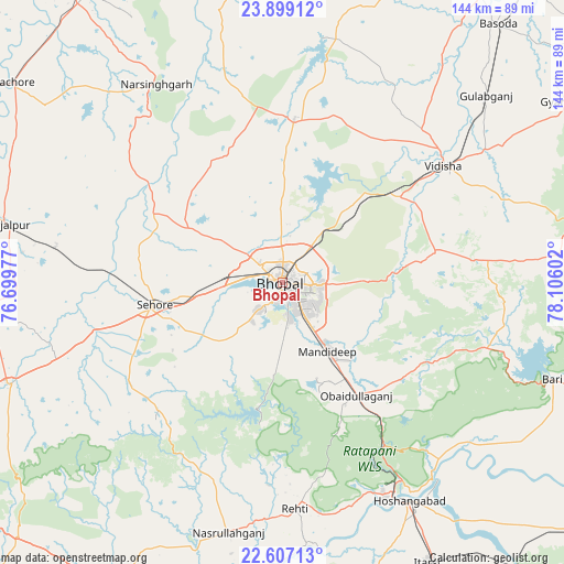
Bhopal GPS coordinates[2]
23° 15' 16.884" North, 77° 24' 10.404" East
| Map corner | latitude | longitude |
|---|---|---|
| Upper-left | 23.89912°, | 76.69977° |
| Center: | 23.25469°, | 77.40289° |
| Lower-right: | 22.60713°, | 78.10602° |
| Map W x H: | 143.7×143.7 km | = 89.3×89.3mi |
| max Lat: | 34.9274° ⇑46.7% North |
| Bhopal: | 23.25469° |
| min Lat: | ⇓53.3% South 8.09008° |
| min Long | Bhopal | max Long |
| 68.82655° | 77.40289° | 96.81° |
| W 41.7%⇐ | ⇒58.3% E |
Elevation
Elevation of Bhopal is 523 m = 1716 ft, and this is 227.4 m = 746 ft above average elevation for this country.
| Max E: |
3681 m = 12077 ft | 16.2% |
| Bhopal | 523 m 1716 ft | |
| Avg. | 295.6 m = 970 ft | |
Min E: |
1 m = 3 ft | 83.8% |
See also: Bhopal elevation on elevation.city.
Geographical zone
Bhopal is located in North Torrid zone (between Equator and Tropic of Cancer). Distance of this Northern Tropic circle is 20.2 km =12.6 mi to North.| Distance of | km | miles | from Bhopal |
|---|---|---|---|
| North Pole | 7421.4 | 4611.4 | to North |
| Arctic Circle | 4815.5 | 2992.2 | to North |
| Tropic Cancer | 20.2 | 12.6 | to North |
| Equator | 2585.7 | 1606.7 | to South |


Nearby cities:
15 places around Bhopal: (largest is in red/bold)
• Berasia
42 km =26.1 mi,  4°
4°
• Chandpura
67.4 km =41.9 mi,  350°
350°
• Garha Brahman
68.4 km =42.5 mi,  356°
356°
• Hoshangābād
65.4 km =40.6 mi,  149°
149°
• Ichhāwar
46.8 km =29.1 mi,  237°
237°
• Mandideep
23.4 km =14.5 mi, 145°
• Narsinghgarh
59.4 km =36.9 mi,  327°
327°
• Nasrullāhganj
64.9 km =40.3 mi,  192°
192°
• Patalpani
65.4 km =40.6 mi, 355°
• Raisen
39.5 km =24.5 mi,  77°
77°
• Rehti
57.6 km =35.8 mi,  176°
176°
• Sehore
33.2 km =20.6 mi,  259°
259°
• Sultānpur
55.8 km =34.7 mi,  103°
103°
• Sānchi
42.8 km =26.6 mi,  52°
52°
• Vidisha
51.4 km =31.9 mi, 54°
Sources, notices
• [Note1] Compared only with cities in India existing in our database
• [Src1] Map data: © OpenStreetMap contributors (CC-BY-SA)
• [Src2] Other city data from geonames.org with taken over terms of usage.
• [Src3] Geographical zone / Annual Mean Temperature by Robert A. Rohde @ Wikipedia
