Talen geodata
Talen (Madhya Pradesh) is a populated place; located in India in Asia/Kolkata (GMT+5.5) time zone. With population of 9,818 people, there are 2967 cities with bigger population in this country. Compared to other cities in India, 55.3% of cities are located further ↓South; 66% of cities are located further →East and 78.4% of cities have lower elevation than Talen. Note1


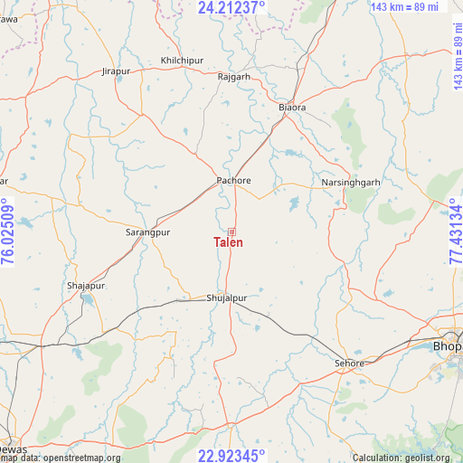
Talen GPS coordinates[2]
23° 34' 10.164" North, 76° 43' 41.556" East
| Map corner | latitude | longitude |
|---|---|---|
| Upper-left | 24.21237°, | 76.02509° |
| Center: | 23.56949°, | 76.72821° |
| Lower-right: | 22.92345°, | 77.43134° |
| Map W x H: | 143.3×143.3 km | = 89×89mi |
| max Lat: | 34.9274° ⇑44.7% North |
| Talen: | 23.56949° |
| min Lat: | ⇓55.3% South 8.09008° |
| min Long | Talen | max Long |
| 68.82655° | 76.72821° | 96.81° |
| W 34%⇐ | ⇒66% E |
Elevation
Elevation of Talen is 436 m = 1430 ft, and this is 140.4 m = 461 ft above average elevation for this country.
| Max E: |
3681 m = 12077 ft | 21.6% |
| Talen | 436 m 1430 ft | |
| Avg. | 295.6 m = 970 ft | |
Min E: |
1 m = 3 ft | 78.4% |
See also: India elevation on elevation.city.
Geographical zone
Talen is located in North temperate zone (between Tropic of Cancer and the Arctic Circle). Distance of this Northern Tropic circle is 14.8 km =9.2 mi to South.| Distance of | km | miles | from Talen |
|---|---|---|---|
| North Pole | 7386.4 | 4589.7 | to North |
| Arctic Circle | 4780.5 | 2970.5 | to North |
| Tropic Cancer | 14.8 | 9.2 | to South |
| Equator | 2620.7 | 1628.4 | to South |


Nearby cities:
15 places around Talen: (largest is in red/bold)
• Akodia
24.8 km =15.4 mi,  212°
212°
• Ashta
61.4 km =38.2 mi,  180°
180°
• Biaora
43.2 km =26.8 mi,  25°
25°
• Chandpura
66 km =41 mi,  61°
61°
• Iklehra
58.3 km =36.2 mi,  216°
216°
• Iāwar
66.5 km =41.3 mi,  200°
200°
• Khata Khedi
66.3 km =41.2 mi, 59°
• Khilchipur
54.4 km =33.8 mi,  343°
343°
• Khujner
26.6 km =16.5 mi,  334°
334°
• Narsinghgarh
40.2 km =25 mi,  67°
67°
• Rājgarh
48.8 km =30.3 mi,  0°
0°
• Sehore
54.8 km =34.1 mi,  138°
138°
• Shujālpur
18.2 km =11.3 mi,  185°
185°
• Shājāpur
48.6 km =30.2 mi,  250°
250°
• Sārangpur
26 km =16.2 mi,  269°
269°
Sources, notices
• [Note1] Compared only with cities in India existing in our database
• [Src1] Map data: © OpenStreetMap contributors (CC-BY-SA)
• [Src2] Other city data from geonames.org with taken over terms of usage.
• [Src3] Geographical zone / Annual Mean Temperature by Robert A. Rohde @ Wikipedia
