Mandideep geodata
Mandideep (Madhya Pradesh) is a populated place; located in India in Asia/Kolkata (GMT+5.5) time zone. With population of 39,898 people, there are 1110 cities with bigger population in this country. Compared to other cities in India, 52.2% of cities are located further ↓South; 56.9% of cities are located further →East and 78.8% of cities have lower elevation than Mandideep. Note1


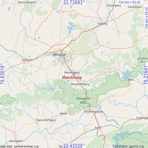
Mandideep GPS coordinates[2]
23° 4' 53.976" North, 77° 31' 59.808" East
| Map corner | latitude | longitude |
|---|---|---|
| Upper-left | 23.72693°, | 76.83016° |
| Center: | 23.08166°, | 77.53328° |
| Lower-right: | 22.43328°, | 78.23641° |
| Map W x H: | 143.8×143.8 km | = 89.4×89.4mi |
| max Lat: | 34.9274° ⇑47.8% North |
| Mandideep: | 23.08166° |
| min Lat: | ⇓52.2% South 8.09008° |
| min Long | Mandideep | max Long |
| 68.82655° | 77.53328° | 96.81° |
| W 43.1%⇐ | ⇒56.9% E |
Elevation
Elevation of Mandideep is 443 m = 1453 ft, and this is 147.4 m = 484 ft above average elevation for this country.
| Max E: |
3681 m = 12077 ft | 21.2% |
| Mandideep | 443 m 1453 ft | |
| Avg. | 295.6 m = 970 ft | |
Min E: |
1 m = 3 ft | 78.8% |
See also: India elevation on elevation.city.
Geographical zone
Mandideep is located in North Torrid zone (between Equator and Tropic of Cancer). Distance of this Northern Tropic circle is 39.5 km =24.5 mi to North.| Distance of | km | miles | from Mandideep |
|---|---|---|---|
| North Pole | 7440.6 | 4623.4 | to North |
| Arctic Circle | 4834.7 | 3004.1 | to North |
| Tropic Cancer | 39.5 | 24.5 | to North |
| Equator | 2566.4 | 1594.7 | to South |


Nearby cities:
15 places around Mandideep: (largest is in red/bold)
• Berasia
62 km =38.5 mi,  350°
350°
• Bhopal
23.4 km =14.5 mi,  325°
325°
• Bābai
58.9 km =36.6 mi,  135°
135°
• Hoshangābād
42.1 km =26.2 mi,  151°
151°
• Ichhāwar
53.1 km =33 mi,  263°
263°
• Itārsi
57 km =35.4 mi,  155°
155°
• Nasrullāhganj
51.8 km =32.2 mi,  211°
211°
• Raisen
37.5 km =23.3 mi,  42°
42°
• Rehti
39.6 km =24.6 mi,  194°
194°
• Sehore
47.8 km =29.7 mi,  285°
285°
• Seoni Mālwa
70.5 km =43.8 mi, 185°
• Sohāgpur
80 km =49.7 mi,  122°
122°
• Sultānpur
41.5 km =25.8 mi,  81°
81°
• Sānchi
49.6 km =30.8 mi,  24°
24°
• Vidisha
57 km =35.4 mi,  29°
29°
Sources, notices
• [Note1] Compared only with cities in India existing in our database
• [Src1] Map data: © OpenStreetMap contributors (CC-BY-SA)
• [Src2] Other city data from geonames.org with taken over terms of usage.
• [Src3] Geographical zone / Annual Mean Temperature by Robert A. Rohde @ Wikipedia
