Sausar geodata
Sausar (Madhya Pradesh) is a populated place; located in India in Asia/Kolkata (GMT+5.5) time zone. With population of 26,704 people, there are 1596 cities with bigger population in this country. Compared to other cities in India, 58.3% of cities are located further ↑North; 57% of cities are located further ←West and 72.8% of cities have lower elevation than Sausar. Note1


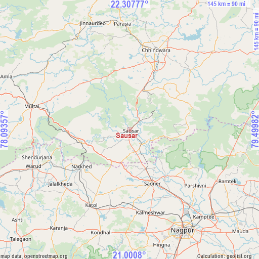
Sausar GPS coordinates[2]
21° 39' 20.736" North, 78° 47' 48.084" East
| Map corner | latitude | longitude |
|---|---|---|
| Upper-left | 22.30777°, | 78.09357° |
| Center: | 21.65576°, | 78.79669° |
| Lower-right: | 21.0008°, | 79.49982° |
| Map W x H: | 145.3×145.3 km | = 90.3×90.3mi |
| max Lat: | 34.9274° ⇑58.3% North |
| Sausar: | 21.65576° |
| min Lat: | ⇓41.7% South 8.09008° |
| min Long | Sausar | max Long |
| 68.82655° | 78.79669° | 96.81° |
| W 57%⇐ | ⇒43% E |
Elevation
Elevation of Sausar is 360 m = 1181 ft, and this is 64.4 m = 211 ft above average elevation for this country.
| Max E: |
3681 m = 12077 ft | 27.2% |
| Sausar | 360 m 1181 ft | |
| Avg. | 295.6 m = 970 ft | |
Min E: |
1 m = 3 ft | 72.8% |
See also: India elevation on elevation.city.
Geographical zone
Sausar is located in North Torrid zone (between Equator and Tropic of Cancer). Distance of this Northern Tropic circle is 198 km =123 mi to North.| Distance of | km | miles | from Sausar |
|---|---|---|---|
| North Pole | 7599.2 | 4721.9 | to North |
| Arctic Circle | 4993.3 | 3102.7 | to North |
| Tropic Cancer | 198 | 123 | to North |
| Equator | 2407.9 | 1496.2 | to South |


Nearby cities:
15 places around Sausar: (largest is in red/bold)
• Chhindwāra
47 km =29.2 mi,  18°
18°
• Kalmeshwar
48.8 km =30.3 mi,  164°
164°
• Khāpa
32.2 km =20 mi,  143°
143°
• Korādi
55.5 km =34.5 mi, 144°
• Kāndri
56.1 km =34.9 mi,  117°
117°
• Kātol
47.7 km =29.6 mi,  207°
207°
• Lodhīkheda
10.4 km =6.5 mi, 141°
• Mansar
56.3 km =35 mi, 120°
• Mohgaon
6.5 km =4 mi,  253°
253°
• Mohpa
38.6 km =24 mi,  174°
174°
• Mowād
41.6 km =25.8 mi,  239°
239°
• Multai
57.2 km =35.5 mi,  283°
283°
• Pāndhurnā
28.7 km =17.8 mi,  256°
256°
• Saoner
32.7 km =20.3 mi, 156°
• Warud
58.2 km =36.2 mi, 249°
Sources, notices
• [Note1] Compared only with cities in India existing in our database
• [Src1] Map data: © OpenStreetMap contributors (CC-BY-SA)
• [Src2] Other city data from geonames.org with taken over terms of usage.
• [Src3] Geographical zone / Annual Mean Temperature by Robert A. Rohde @ Wikipedia
