Pāndhurnā geodata
Pāndhurnā (Madhya Pradesh) is a populated place; located in India in Asia/Kolkata (GMT+5.5) time zone. With population of 43,630 people, there are 1015 cities with bigger population in this country. Compared to other cities in India, 58.6% of cities are located further ↑North; 54.4% of cities are located further ←West and 80.7% of cities have lower elevation than Pāndhurnā. Note1


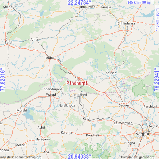
Pāndhurnā GPS coordinates[2]
21° 35' 44.016" North, 78° 31' 34.608" East
| Map corner | latitude | longitude |
|---|---|---|
| Upper-left | 22.24784°, | 77.82316° |
| Center: | 21.59556°, | 78.52628° |
| Lower-right: | 20.94033°, | 79.22941° |
| Map W x H: | 145.4×145.4 km | = 90.3×90.3mi |
| max Lat: | 34.9274° ⇑58.6% North |
| Pāndhurnā: | 21.59556° |
| min Lat: | ⇓41.4% South 8.09008° |
| min Long | Pāndhurnā | max Long |
| 68.82655° | 78.52628° | 96.81° |
| W 54.4%⇐ | ⇒45.6% E |
Elevation
Elevation of Pāndhurnā is 470 m = 1542 ft, and this is 174.4 m = 572 ft above average elevation for this country.
| Max E: |
3681 m = 12077 ft | 19.3% |
| Pāndhurnā | 470 m 1542 ft | |
| Avg. | 295.6 m = 970 ft | |
Min E: |
1 m = 3 ft | 80.7% |
See also: Pāndhurnā elevation on elevation.city.
Geographical zone
Pāndhurnā is located in North Torrid zone (between Equator and Tropic of Cancer). Distance of this Northern Tropic circle is 204.7 km =127.2 mi to North.| Distance of | km | miles | from Pāndhurnā |
|---|---|---|---|
| North Pole | 7605.9 | 4726.1 | to North |
| Arctic Circle | 5000 | 3106.9 | to North |
| Tropic Cancer | 204.7 | 127.2 | to North |
| Equator | 2401.2 | 1492 | to South |


Nearby cities:
15 places around Pāndhurnā: (largest is in red/bold)
• Amla
55.1 km =34.2 mi,  311°
311°
• Chhindwāra
66.7 km =41.4 mi,  39°
39°
• Jāmai
67.2 km =41.8 mi,  5°
5°
• Kalmeshwar
57.4 km =35.7 mi,  134°
134°
• Khāpa
50.9 km =31.6 mi,  112°
112°
• Kātol
36.3 km =22.6 mi,  170°
170°
• Lodhīkheda
34.4 km =21.4 mi,  92°
92°
• Mohgaon
22.3 km =13.9 mi,  77°
77°
• Mohpa
44.6 km =27.7 mi,  135°
135°
• Morsi
60.3 km =37.5 mi,  241°
241°
• Mowād
16.5 km =10.3 mi,  208°
208°
• Multai
34.2 km =21.3 mi, 305°
• Saoner
47.1 km =29.3 mi,  119°
119°
• Sausar
28.7 km =17.8 mi, 76°
• Warud
29.9 km =18.6 mi, 242°
Sources, notices
• [Note1] Compared only with cities in India existing in our database
• [Src1] Map data: © OpenStreetMap contributors (CC-BY-SA)
• [Src2] Other city data from geonames.org with taken over terms of usage.
• [Src3] Geographical zone / Annual Mean Temperature by Robert A. Rohde @ Wikipedia
