Kāndri geodata
Kāndri (Maharashtra) is a populated place; located in India in Asia/Kolkata (GMT+5.5) time zone. With population of 8,315 people, there are 3099 cities with bigger population in this country. Compared to other cities in India, 59.4% of cities are located further ↑North; 61.6% of cities are located further ←West and 71.6% of cities have lower elevation than Kāndri. Note1


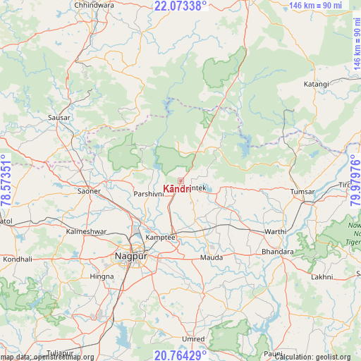
Kāndri GPS coordinates[2]
21° 25' 13.08" North, 79° 16' 35.868" East
| Map corner | latitude | longitude |
|---|---|---|
| Upper-left | 22.07338°, | 78.57351° |
| Center: | 21.4203°, | 79.27663° |
| Lower-right: | 20.76429°, | 79.97976° |
| Map W x H: | 145.6×145.6 km | = 90.5×90.5mi |
| max Lat: | 34.9274° ⇑59.4% North |
| Kāndri: | 21.4203° |
| min Lat: | ⇓40.6% South 8.09008° |
| min Long | Kāndri | max Long |
| 68.82655° | 79.27663° | 96.81° |
| W 61.6%⇐ | ⇒38.4% E |
Elevation
Elevation of Kāndri is 344 m = 1129 ft, and this is 48.4 m = 159 ft above average elevation for this country.
| Max E: |
3681 m = 12077 ft | 28.4% |
| Kāndri | 344 m 1129 ft | |
| Avg. | 295.6 m = 970 ft | |
Min E: |
1 m = 3 ft | 71.6% |
See also: India elevation on elevation.city.
Geographical zone
Kāndri is located in North Torrid zone (between Equator and Tropic of Cancer). Distance of this Northern Tropic circle is 224.2 km =139.3 mi to North.| Distance of | km | miles | from Kāndri |
|---|---|---|---|
| North Pole | 7625.3 | 4738.1 | to North |
| Arctic Circle | 5019.5 | 3119 | to North |
| Tropic Cancer | 224.2 | 139.3 | to North |
| Equator | 2381.7 | 1479.9 | to South |


Nearby cities:
15 places around Kāndri: (largest is in red/bold)
• Bhandāra
47.7 km =29.6 mi,  126°
126°
• Chicholi
44.3 km =27.5 mi,  82°
82°
• Hīrāpur Hamesha
54.8 km =34.1 mi,  74°
74°
• Kalmeshwar
42.5 km =26.4 mi,  240°
240°
• Khāpa
30.5 km =19 mi,  270°
270°
• Korādi
26.1 km =16.2 mi,  222°
222°
• Kāmthi
24.1 km =15 mi,  199°
199°
• Lodhīkheda
46.8 km =29.1 mi,  292°
292°
• Mansar
3 km =1.9 mi,  206°
206°
• Mohpa
47.9 km =29.8 mi,  255°
255°
• Nagpur
36.4 km =22.6 mi, 213°
• Rāmtek
5.9 km =3.7 mi,  117°
117°
• Saoner
37 km =23 mi, 263°
• Tirodi
54.4 km =33.8 mi,  57°
57°
• Tumsar
47.5 km =29.5 mi,  94°
94°
Sources, notices
• [Note1] Compared only with cities in India existing in our database
• [Src1] Map data: © OpenStreetMap contributors (CC-BY-SA)
• [Src2] Other city data from geonames.org with taken over terms of usage.
• [Src3] Geographical zone / Annual Mean Temperature by Robert A. Rohde @ Wikipedia
