Mansar geodata
Mansar (Maharashtra) is a populated place; located in India in Asia/Kolkata (GMT+5.5) time zone. With population of 6,901 people, there are 3220 cities with bigger population in this country. Compared to other cities in India, 59.5% of cities are located further ↑North; 61.4% of cities are located further ←West and 70.3% of cities have lower elevation than Mansar. Note1


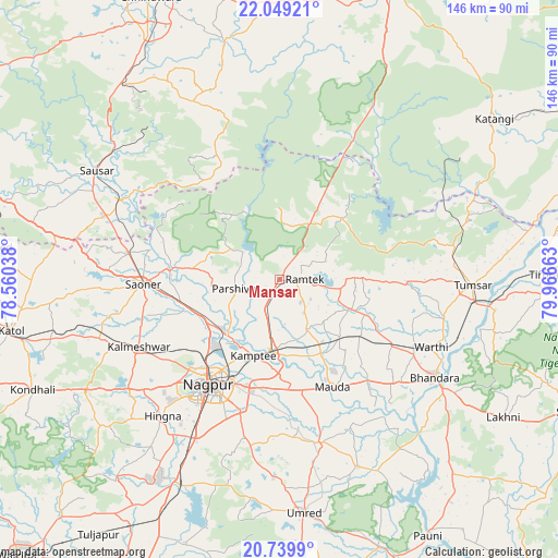
Mansar GPS coordinates[2]
21° 23' 45.672" North, 79° 15' 48.6" East
| Map corner | latitude | longitude |
|---|---|---|
| Upper-left | 22.04921°, | 78.56038° |
| Center: | 21.39602°, | 79.2635° |
| Lower-right: | 20.7399°, | 79.96663° |
| Map W x H: | 145.6×145.6 km | = 90.5×90.5mi |
| max Lat: | 34.9274° ⇑59.5% North |
| Mansar: | 21.39602° |
| min Lat: | ⇓40.5% South 8.09008° |
| min Long | Mansar | max Long |
| 68.82655° | 79.2635° | 96.81° |
| W 61.4%⇐ | ⇒38.6% E |
Elevation
Elevation of Mansar is 330 m = 1083 ft, and this is 34.4 m = 113 ft above average elevation for this country.
| Max E: |
3681 m = 12077 ft | 29.7% |
| Mansar | 330 m 1083 ft | |
| Avg. | 295.6 m = 970 ft | |
Min E: |
1 m = 3 ft | 70.3% |
See also: India elevation on elevation.city.
Geographical zone
Mansar is located in North Torrid zone (between Equator and Tropic of Cancer). Distance of this Northern Tropic circle is 226.9 km =141 mi to North.| Distance of | km | miles | from Mansar |
|---|---|---|---|
| North Pole | 7628 | 4739.8 | to North |
| Arctic Circle | 5022.2 | 3120.6 | to North |
| Tropic Cancer | 226.9 | 141 | to North |
| Equator | 2379 | 1478.2 | to South |


Nearby cities:
15 places around Mansar: (largest is in red/bold)
• Bhandāra
47.3 km =29.4 mi,  122°
122°
• Chicholi
46.1 km =28.6 mi,  79°
79°
• Hīrāpur Hamesha
56.9 km =35.4 mi,  71°
71°
• Kalmeshwar
40 km =24.9 mi,  242°
242°
• Khāpa
29.3 km =18.2 mi,  275°
275°
• Korādi
23.2 km =14.4 mi,  224°
224°
• Kāmthi
21.1 km =13.1 mi,  198°
198°
• Kāndri
3 km =1.9 mi,  26°
26°
• Lodhīkheda
46.7 km =29 mi,  296°
296°
• Mohpa
45.9 km =28.5 mi,  257°
257°
• Nagpur
33.4 km =20.8 mi,  213°
213°
• Rāmtek
6.6 km =4.1 mi,  90°
90°
• Saoner
35.4 km =22 mi,  268°
268°
• Sausar
56.3 km =35 mi, 300°
• Tumsar
48.7 km =30.3 mi, 91°
Sources, notices
• [Note1] Compared only with cities in India existing in our database
• [Src1] Map data: © OpenStreetMap contributors (CC-BY-SA)
• [Src2] Other city data from geonames.org with taken over terms of usage.
• [Src3] Geographical zone / Annual Mean Temperature by Robert A. Rohde @ Wikipedia
