Mohgaon geodata
Mohgaon (Madhya Pradesh) is a populated place; located in India in Asia/Kolkata (GMT+5.5) time zone. With population of 10,446 people, there are 2896 cities with bigger population in this country. Compared to other cities in India, 58.4% of cities are located further ↑North; 56.2% of cities are located further ←West and 73.8% of cities have lower elevation than Mohgaon. Note1


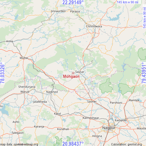
Mohgaon GPS coordinates[2]
21° 38' 21.876" North, 78° 44' 10.968" East
| Map corner | latitude | longitude |
|---|---|---|
| Upper-left | 22.29149°, | 78.03326° |
| Center: | 21.63941°, | 78.73638° |
| Lower-right: | 20.98437°, | 79.43951° |
| Map W x H: | 145.3×145.3 km | = 90.3×90.3mi |
| max Lat: | 34.9274° ⇑58.4% North |
| Mohgaon: | 21.63941° |
| min Lat: | ⇓41.6% South 8.09008° |
| min Long | Mohgaon | max Long |
| 68.82655° | 78.73638° | 96.81° |
| W 56.2%⇐ | ⇒43.8% E |
Elevation
Elevation of Mohgaon is 371 m = 1217 ft, and this is 75.4 m = 247 ft above average elevation for this country.
| Max E: |
3681 m = 12077 ft | 26.2% |
| Mohgaon | 371 m 1217 ft | |
| Avg. | 295.6 m = 970 ft | |
Min E: |
1 m = 3 ft | 73.8% |
See also: India elevation on elevation.city.
Geographical zone
Mohgaon is located in North Torrid zone (between Equator and Tropic of Cancer). Distance of this Northern Tropic circle is 199.8 km =124.1 mi to North.| Distance of | km | miles | from Mohgaon |
|---|---|---|---|
| North Pole | 7601 | 4723 | to North |
| Arctic Circle | 4995.1 | 3103.8 | to North |
| Tropic Cancer | 199.8 | 124.1 | to North |
| Equator | 2406.1 | 1495.1 | to South |


Nearby cities:
15 places around Mohgaon: (largest is in red/bold)
• Chhindwāra
50.9 km =31.6 mi,  24°
24°
• Kalmeshwar
49.1 km =30.5 mi,  157°
157°
• Khāpa
35 km =21.7 mi,  133°
133°
• Korādi
58 km =36 mi,  138°
138°
• Kāndri
61 km =37.9 mi,  113°
113°
• Kātol
43.5 km =27 mi,  200°
200°
• Lodhīkheda
14.2 km =8.8 mi,  116°
116°
• Mansar
60.9 km =37.8 mi, 116°
• Mohpa
37.9 km =23.5 mi,  165°
165°
• Mowād
35.3 km =21.9 mi,  236°
236°
• Multai
51.7 km =32.1 mi,  286°
286°
• Pāndhurnā
22.3 km =13.9 mi,  257°
257°
• Saoner
34.2 km =21.3 mi,  145°
145°
• Sausar
6.5 km =4 mi,  73°
73°
• Warud
51.8 km =32.2 mi,  248°
248°
Sources, notices
• [Note1] Compared only with cities in India existing in our database
• [Src1] Map data: © OpenStreetMap contributors (CC-BY-SA)
• [Src2] Other city data from geonames.org with taken over terms of usage.
• [Src3] Geographical zone / Annual Mean Temperature by Robert A. Rohde @ Wikipedia
