Multai geodata
Multai (Madhya Pradesh) is a populated place; located in India in Asia/Kolkata (GMT+5.5) time zone. With population of 22,029 people, there are 1903 cities with bigger population in this country. Compared to other cities in India, 57.5% of cities are located further ↑North; 51.8% of cities are located further ←West and 93.2% of cities have lower elevation than Multai. Note1


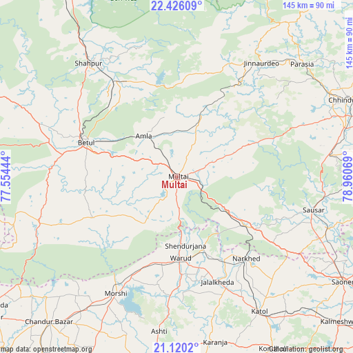
Multai GPS coordinates[2]
21° 46' 28.668" North, 78° 15' 27.216" East
| Map corner | latitude | longitude |
|---|---|---|
| Upper-left | 22.42609°, | 77.55444° |
| Center: | 21.77463°, | 78.25756° |
| Lower-right: | 21.1202°, | 78.96069° |
| Map W x H: | 145.2×145.2 km | = 90.2×90.2mi |
| max Lat: | 34.9274° ⇑57.5% North |
| Multai: | 21.77463° |
| min Lat: | ⇓42.5% South 8.09008° |
| min Long | Multai | max Long |
| 68.82655° | 78.25756° | 96.81° |
| W 51.8%⇐ | ⇒48.2% E |
Elevation
Elevation of Multai is 758 m = 2487 ft, and this is 462.4 m = 1517 ft above average elevation for this country.
| Max E: |
3681 m = 12077 ft | 6.8% |
| Multai | 758 m 2487 ft | |
| Avg. | 295.6 m = 970 ft | |
Min E: |
1 m = 3 ft | 93.2% |
See also: India elevation on elevation.city.
Geographical zone
Multai is located in North Torrid zone (between Equator and Tropic of Cancer). Distance of this Northern Tropic circle is 184.8 km =114.8 mi to North.| Distance of | km | miles | from Multai |
|---|---|---|---|
| North Pole | 7586 | 4713.7 | to North |
| Arctic Circle | 4980.1 | 3094.5 | to North |
| Tropic Cancer | 184.8 | 114.8 | to North |
| Equator | 2421.1 | 1504.4 | to South |


Nearby cities:
15 places around Multai: (largest is in red/bold)
• Amla
21.4 km =13.3 mi,  321°
321°
• Betūl
39.3 km =24.4 mi,  290°
290°
• Betūl Bazār
35.1 km =21.8 mi,  284°
284°
• Bhainsdehi
66.4 km =41.3 mi,  257°
257°
• Jāmai
58.2 km =36.2 mi,  36°
36°
• Kātol
65.2 km =40.5 mi,  148°
148°
• Lodhīkheda
65.7 km =40.8 mi,  108°
108°
• Mohgaon
51.7 km =32.1 mi, 106°
• Morsi
54.5 km =33.9 mi,  207°
207°
• Mowād
39.8 km =24.7 mi, 149°
• Panara
56.7 km =35.2 mi,  32°
32°
• Pāndhurnā
34.2 km =21.3 mi,  125°
125°
• Sausar
57.2 km =35.5 mi,  103°
103°
• Shāhpur
59.1 km =36.7 mi, 322°
• Warud
33.8 km =21 mi,  177°
177°
Sources, notices
• [Note1] Compared only with cities in India existing in our database
• [Src1] Map data: © OpenStreetMap contributors (CC-BY-SA)
• [Src2] Other city data from geonames.org with taken over terms of usage.
• [Src3] Geographical zone / Annual Mean Temperature by Robert A. Rohde @ Wikipedia
