Bilaspur geodata
Bilaspur (Himachal Pradesh) is a populated place; located in India in Asia/Kolkata (GMT+5.5) time zone. With population of 14,037 people, there are 2563 cities with bigger population in this country. Compared to other cities in India, 96.6% of cities are located further ↓South; 65.6% of cities are located further →East and 82.2% of cities have lower elevation than Bilaspur. Note1


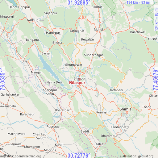
Bilaspur GPS coordinates[2]
31° 19' 48.972" North, 76° 45' 23.868" East
| Map corner | latitude | longitude |
|---|---|---|
| Upper-left | 31.92895°, | 76.05351° |
| Center: | 31.33027°, | 76.75663° |
| Lower-right: | 30.72776°, | 77.45976° |
| Map W x H: | 133.6×133.6 km | = 83×83mi |
| max Lat: | 34.9274° ⇑3.4% North |
| Bilaspur: | 31.33027° |
| min Lat: | ⇓96.6% South 8.09008° |
| min Long | Bilaspur | max Long |
| 68.82655° | 76.75663° | 96.81° |
| W 34.4%⇐ | ⇒65.6% E |
Elevation
Elevation of Bilaspur is 496 m = 1627 ft, and this is 200.4 m = 657 ft above average elevation for this country.
| Max E: |
3681 m = 12077 ft | 17.8% |
| Bilaspur | 496 m 1627 ft | |
| Avg. | 295.6 m = 970 ft | |
Min E: |
1 m = 3 ft | 82.2% |
See also: India elevation on elevation.city.
Geographical zone
Bilaspur is located in North temperate zone (between Tropic of Cancer and the Arctic Circle). Distance of this Northern Tropic circle is 877.7 km =545.4 mi to South.| Distance of | km | miles | from Bilaspur |
|---|---|---|---|
| North Pole | 6523.5 | 4053.5 | to North |
| Arctic Circle | 3917.6 | 2434.3 | to North |
| Tropic Cancer | 877.7 | 545.4 | to South |
| Equator | 3483.6 | 2164.6 | to South |


Nearby cities:
15 places around Bilaspur: (largest is in red/bold)
• Anandpur
26.2 km =16.3 mi,  247°
247°
• Arki
28.1 km =17.5 mi,  134°
134°
• Baddi
41.5 km =25.8 mi,  175°
175°
• Ghumārwīn
13 km =8.1 mi,  342°
342°
• Hamīrpur
45.1 km =28 mi,  330°
330°
• Jutogh
42.8 km =26.6 mi, 126°
• Mandi
45.6 km =28.3 mi,  21°
21°
• Nangal
36.8 km =22.9 mi,  280°
280°
• Nālāgarh
32.2 km =20 mi,  185°
185°
• Nūrpur Kalān
31.7 km =19.7 mi,  235°
235°
• Sabāthu
45.4 km =28.2 mi,  150°
150°
• Santokhgarh
41.7 km =25.9 mi,  273°
273°
• Sarka Ghāt
41 km =25.5 mi,  357°
357°
• Seoni
36.2 km =22.5 mi,  105°
105°
• Sundarnagar
26.8 km =16.7 mi,  31°
31°
Sources, notices
• [Note1] Compared only with cities in India existing in our database
• [Src1] Map data: © OpenStreetMap contributors (CC-BY-SA)
• [Src2] Other city data from geonames.org with taken over terms of usage.
• [Src3] Geographical zone / Annual Mean Temperature by Robert A. Rohde @ Wikipedia
