Nangal geodata
Nangal (Punjab) is a populated place; located in India in Asia/Kolkata (GMT+5.5) time zone. With population of 48,497 people, there are 910 cities with bigger population in this country. Compared to other cities in India, 96.7% of cities are located further ↓South; 69.6% of cities are located further →East and 73.3% of cities have lower elevation than Nangal. Note1


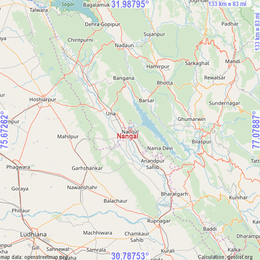
Nangal GPS coordinates[2]
31° 23' 22.776" North, 76° 22' 32.664" East
| Map corner | latitude | longitude |
|---|---|---|
| Upper-left | 31.98795°, | 75.67262° |
| Center: | 31.38966°, | 76.37574° |
| Lower-right: | 30.78753°, | 77.07887° |
| Map W x H: | 133.5×133.5 km | = 83×83mi |
| max Lat: | 34.9274° ⇑3.3% North |
| Nangal: | 31.38966° |
| min Lat: | ⇓96.7% South 8.09008° |
| min Long | Nangal | max Long |
| 68.82655° | 76.37574° | 96.81° |
| W 30.4%⇐ | ⇒69.6% E |
Elevation
Elevation of Nangal is 364 m = 1194 ft, and this is 68.4 m = 224 ft above average elevation for this country.
| Max E: |
3681 m = 12077 ft | 26.7% |
| Nangal | 364 m 1194 ft | |
| Avg. | 295.6 m = 970 ft | |
Min E: |
1 m = 3 ft | 73.3% |
See also: Nangal elevation on elevation.city.
Geographical zone
Nangal is located in North temperate zone (between Tropic of Cancer and the Arctic Circle). Distance of this Northern Tropic circle is 884.3 km =549.5 mi to South.| Distance of | km | miles | from Nangal |
|---|---|---|---|
| North Pole | 6516.9 | 4049.4 | to North |
| Arctic Circle | 3911 | 2430.2 | to North |
| Tropic Cancer | 884.3 | 549.5 | to South |
| Equator | 3490.2 | 2168.7 | to South |


Nearby cities:
15 places around Nangal: (largest is in red/bold)
• Anandpur
20.6 km =12.8 mi,  144°
144°
• Banga
42.5 km =26.4 mi,  238°
238°
• Bilaspur
36.8 km =22.9 mi,  100°
100°
• Bālāchor
37.3 km =23.2 mi,  190°
190°
• Gagret
42.2 km =26.2 mi,  315°
315°
• Garhshankar
29.5 km =18.3 mi,  228°
228°
• Ghumārwīn
32.7 km =20.3 mi,  79°
79°
• Hamīrpur
35.7 km =22.2 mi,  23°
23°
• Hoshiārpur
46.9 km =29.1 mi,  290°
290°
• Nawanshahr
38.4 km =23.9 mi,  219°
219°
• Nādaun
43.8 km =27.2 mi,  355°
355°
• Nūrpur Kalān
26.8 km =16.7 mi,  157°
157°
• Rāhon
44.7 km =27.8 mi,  213°
213°
• Santokhgarh
6.9 km =4.3 mi, 232°
• Una
13.1 km =8.1 mi,  309°
309°
Sources, notices
• [Note1] Compared only with cities in India existing in our database
• [Src1] Map data: © OpenStreetMap contributors (CC-BY-SA)
• [Src2] Other city data from geonames.org with taken over terms of usage.
• [Src3] Geographical zone / Annual Mean Temperature by Robert A. Rohde @ Wikipedia
