Inda Chhoi geodata
Inda Chhoi (Haryana) is a populated place; located in India in Asia/Kolkata (GMT+5.5) time zone. With population of 7,000 people, there are 3209 cities with bigger population in this country. Compared to other cities in India, 91.7% of cities are located further ↓South; 75.7% of cities are located further →East and 56.2% of cities have lower elevation than Inda Chhoi. Note1


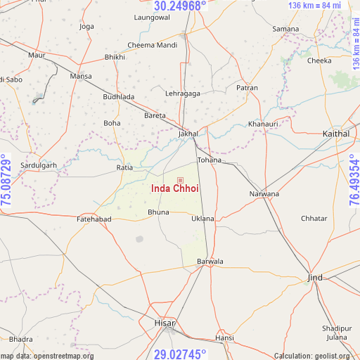
Inda Chhoi GPS coordinates[2]
29° 38' 25.512" North, 75° 47' 25.476" East
| Map corner | latitude | longitude |
|---|---|---|
| Upper-left | 30.24968°, | 75.08729° |
| Center: | 29.64042°, | 75.79041° |
| Lower-right: | 29.02745°, | 76.49354° |
| Map W x H: | 135.9×135.9 km | = 84.4×84.4mi |
| max Lat: | 34.9274° ⇑8.3% North |
| Inda Chhoi: | 29.64042° |
| min Lat: | ⇓91.7% South 8.09008° |
| min Long | Inda Chhoi | max Long |
| 68.82655° | 75.79041° | 96.81° |
| W 24.3%⇐ | ⇒75.7% E |
Elevation
Elevation of Inda Chhoi is 231 m = 758 ft, and this is 64.6 m = 212 ft below average elevation for this country.
| Max E: |
3681 m = 12077 ft | 43.8% |
| Avg. | 295.6 m = 970 ft | |
| Inda Chhoi | 231 m = 758 ft | |
Min E: |
1 m = 3 ft | 56.2% |
See also: India elevation on elevation.city.
Geographical zone
Inda Chhoi is located in North temperate zone (between Tropic of Cancer and the Arctic Circle). Distance of this Northern Tropic circle is 689.8 km =428.6 mi to South.| Distance of | km | miles | from Inda Chhoi |
|---|---|---|---|
| North Pole | 6711.4 | 4170.3 | to North |
| Arctic Circle | 4105.5 | 2551 | to North |
| Tropic Cancer | 689.8 | 428.6 | to South |
| Equator | 3295.7 | 2047.9 | to South |


Nearby cities:
15 places around Inda Chhoi: (largest is in red/bold)
• Akālgarh
22.3 km =13.9 mi,  25°
25°
• Bara Uchāna
42.1 km =26.2 mi,  117°
117°
• Barwāla
32.4 km =20.1 mi,  159°
159°
• Bhīkhi
52.7 km =32.7 mi,  332°
332°
• Budhlāda
38.8 km =24.1 mi, 325°
• Dirba
51.9 km =32.2 mi,  22°
22°
• Fatehābād
35.2 km =21.9 mi,  246°
246°
• Gorakhpur
24.3 km =15.1 mi,  208°
208°
• Jākhal
17.6 km =10.9 mi,  10°
10°
• Mānsa
53.9 km =33.5 mi,  315°
315°
• Narwāna
32.1 km =19.9 mi,  98°
98°
• Ratia
21.4 km =13.3 mi,  285°
285°
• Sardulgarh
53.9 km =33.5 mi,  276°
276°
• Tohāna
13.7 km =8.5 mi,  53°
53°
• Uklāna
16.7 km =10.4 mi,  149°
149°
Sources, notices
• [Note1] Compared only with cities in India existing in our database
• [Src1] Map data: © OpenStreetMap contributors (CC-BY-SA)
• [Src2] Other city data from geonames.org with taken over terms of usage.
• [Src3] Geographical zone / Annual Mean Temperature by Robert A. Rohde @ Wikipedia
