Gorakhpur geodata
Gorakhpur (Haryana) is a populated place; located in India in Asia/Kolkata (GMT+5.5) time zone. With population of 1,324,570 people, there are 22 cities with bigger population in this country. Compared to other cities in India, 90.9% of cities are located further ↓South; 76.8% of cities are located further →East and 53% of cities have lower elevation than Gorakhpur. Note1


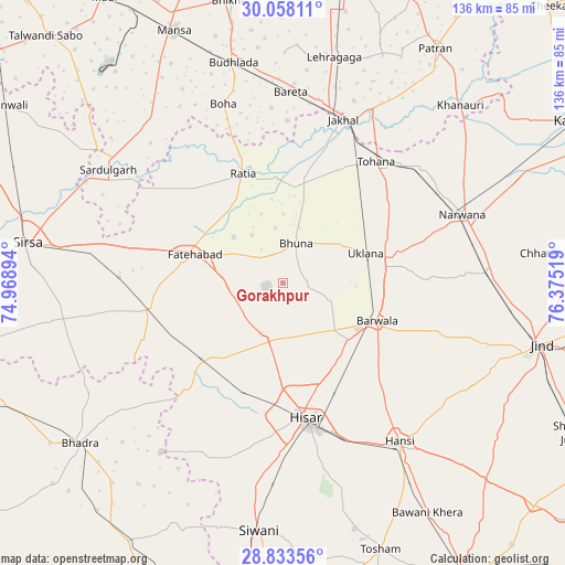
Gorakhpur GPS coordinates[2]
29° 26' 51.648" North, 75° 40' 19.416" East
| Map corner | latitude | longitude |
|---|---|---|
| Upper-left | 30.05811°, | 74.96894° |
| Center: | 29.44768°, | 75.67206° |
| Lower-right: | 28.83356°, | 76.37519° |
| Map W x H: | 136.2×136.2 km | = 84.6×84.6mi |
| max Lat: | 34.9274° ⇑9.1% North |
| Gorakhpur: | 29.44768° |
| min Lat: | ⇓90.9% South 8.09008° |
| min Long | Gorakhpur | max Long |
| 68.82655° | 75.67206° | 96.81° |
| W 23.2%⇐ | ⇒76.8% E |
Elevation
Elevation of Gorakhpur is 218 m = 715 ft, and this is 77.6 m = 255 ft below average elevation for this country.
| Max E: |
3681 m = 12077 ft | 47% |
| Avg. | 295.6 m = 970 ft | |
| Gorakhpur | 218 m = 715 ft | |
Min E: |
1 m = 3 ft | 53% |
See also: Gorakhpur elevation on elevation.city.
Geographical zone
Gorakhpur is located in North temperate zone (between Tropic of Cancer and the Arctic Circle). Distance of this Northern Tropic circle is 668.4 km =415.3 mi to South.| Distance of | km | miles | from Gorakhpur |
|---|---|---|---|
| North Pole | 6732.8 | 4183.6 | to North |
| Arctic Circle | 4126.9 | 2564.3 | to North |
| Tropic Cancer | 668.4 | 415.3 | to South |
| Equator | 3274.3 | 2034.6 | to South |


Nearby cities:
15 places around Gorakhpur: (largest is in red/bold)
• Akālgarh
46.6 km =29 mi,  27°
27°
• Bara Uchāna
49 km =30.4 mi,  87°
87°
• Barwāla
24.5 km =15.2 mi,  111°
111°
• Budhlāda
54.5 km =33.9 mi,  348°
348°
• Fatehābād
22.3 km =13.9 mi,  289°
289°
• Hisar
33 km =20.5 mi,  171°
171°
• Hānsi
47.6 km =29.6 mi,  143°
143°
• Inda Chhoi
24.3 km =15.1 mi, 28°
• Jākhal
41.4 km =25.7 mi,  20°
20°
• Narwāna
46.4 km =28.8 mi,  68°
68°
• Nārnaund
52.2 km =32.4 mi,  118°
118°
• Ratia
28.5 km =17.7 mi,  341°
341°
• Sardulgarh
50.2 km =31.2 mi,  302°
302°
• Tohāna
37.1 km =23.1 mi,  37°
37°
• Uklāna
21.2 km =13.2 mi, 70°
Sources, notices
• [Note1] Compared only with cities in India existing in our database
• [Src1] Map data: © OpenStreetMap contributors (CC-BY-SA)
• [Src2] Other city data from geonames.org with taken over terms of usage.
• [Src3] Geographical zone / Annual Mean Temperature by Robert A. Rohde @ Wikipedia
