Rāmpura geodata
Rāmpura (Punjab) is a populated place; located in India in Asia/Kolkata (GMT+5.5) time zone. With population of 45,639 people, there are 970 cities with bigger population in this country. Compared to other cities in India, 93.6% of cities are located further ↓South; 80.7% of cities are located further →East and 53% of cities have lower elevation than Rāmpura. Note1


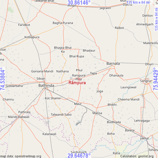
Rāmpura GPS coordinates[2]
30° 15' 21.6" North, 75° 14' 28.176" East
| Map corner | latitude | longitude |
|---|---|---|
| Upper-left | 30.86146°, | 74.53804° |
| Center: | 30.256°, | 75.24116° |
| Lower-right: | 29.64678°, | 75.94429° |
| Map W x H: | 135.1×135.1 km | = 83.9×83.9mi |
| max Lat: | 34.9274° ⇑6.4% North |
| Rāmpura: | 30.256° |
| min Lat: | ⇓93.6% South 8.09008° |
| min Long | Rāmpura | max Long |
| 68.82655° | 75.24116° | 96.81° |
| W 19.3%⇐ | ⇒80.7% E |
Elevation
Elevation of Rāmpura is 218 m = 715 ft, and this is 77.6 m = 255 ft below average elevation for this country.
| Max E: |
3681 m = 12077 ft | 47% |
| Avg. | 295.6 m = 970 ft | |
| Rāmpura | 218 m = 715 ft | |
Min E: |
1 m = 3 ft | 53% |
See also: Rāmpura elevation on elevation.city.
Geographical zone
Rāmpura is located in North temperate zone (between Tropic of Cancer and the Arctic Circle). Distance of this Northern Tropic circle is 758.2 km =471.1 mi to South.| Distance of | km | miles | from Rāmpura |
|---|---|---|---|
| North Pole | 6642.9 | 4127.7 | to North |
| Arctic Circle | 4037 | 2508.5 | to North |
| Tropic Cancer | 758.2 | 471.1 | to South |
| Equator | 3364.2 | 2090.4 | to South |


Nearby cities:
15 places around Rāmpura: (largest is in red/bold)
• Badhni Kalān
47.5 km =29.5 mi,  5°
5°
• Barnāla
32.3 km =20.1 mi,  65°
65°
• Bathinda
29.5 km =18.3 mi,  259°
259°
• Bhadaur
26 km =16.2 mi,  19°
19°
• Bhīkhi
35.7 km =22.2 mi,  127°
127°
• Budhlāda
47.8 km =29.7 mi,  139°
139°
• Bāgha Purāna
50 km =31.1 mi,  344°
344°
• Dhanaula
32 km =19.9 mi,  84°
84°
• Jaito
39.9 km =24.8 mi,  302°
302°
• Kotkapura
53.3 km =33.1 mi,  312°
312°
• Kālānwāli
53.4 km =33.2 mi,  209°
209°
• Laungowāl
42.8 km =26.6 mi,  99°
99°
• Maur
19.2 km =11.9 mi,  177°
177°
• Mānsa
33.5 km =20.8 mi,  152°
152°
• Sunām
55.5 km =34.5 mi, 104°
Sources, notices
• [Note1] Compared only with cities in India existing in our database
• [Src1] Map data: © OpenStreetMap contributors (CC-BY-SA)
• [Src2] Other city data from geonames.org with taken over terms of usage.
• [Src3] Geographical zone / Annual Mean Temperature by Robert A. Rohde @ Wikipedia
