Sabalgarh geodata
Sabalgarh (Madhya Pradesh) is a populated place; located in India in Asia/Kolkata (GMT+5.5) time zone. With population of 31,032 people, there are 1394 cities with bigger population in this country. Compared to other cities in India, 72.4% of cities are located further ↓South; 58.3% of cities are located further →East and 51.1% of cities have lower elevation than Sabalgarh. Note1


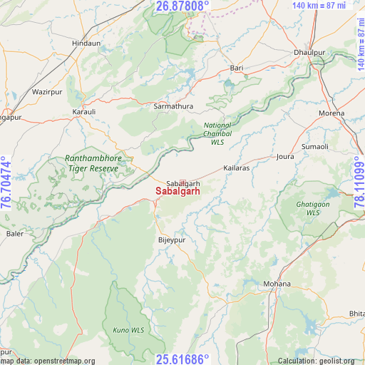
Sabalgarh GPS coordinates[2]
26° 14' 57.048" North, 77° 24' 28.296" East
| Map corner | latitude | longitude |
|---|---|---|
| Upper-left | 26.87808°, | 76.70474° |
| Center: | 26.24918°, | 77.40786° |
| Lower-right: | 25.61686°, | 78.11099° |
| Map W x H: | 140.2×140.2 km | = 87.1×87.1mi |
| max Lat: | 34.9274° ⇑27.6% North |
| Sabalgarh: | 26.24918° |
| min Lat: | ⇓72.4% South 8.09008° |
| min Long | Sabalgarh | max Long |
| 68.82655° | 77.40786° | 96.81° |
| W 41.7%⇐ | ⇒58.3% E |
Elevation
Elevation of Sabalgarh is 208 m = 682 ft, and this is 87.6 m = 287 ft below average elevation for this country.
| Max E: |
3681 m = 12077 ft | 48.9% |
| Avg. | 295.6 m = 970 ft | |
| Sabalgarh | 208 m = 682 ft | |
Min E: |
1 m = 3 ft | 51.1% |
See also: India elevation on elevation.city.
Geographical zone
Sabalgarh is located in North temperate zone (between Tropic of Cancer and the Arctic Circle). Distance of this Northern Tropic circle is 312.7 km =194.3 mi to South.| Distance of | km | miles | from Sabalgarh |
|---|---|---|---|
| North Pole | 7088.4 | 4404.5 | to North |
| Arctic Circle | 4482.5 | 2785.3 | to North |
| Tropic Cancer | 312.7 | 194.3 | to South |
| Equator | 2918.6 | 1813.5 | to South |


Nearby cities:
15 places around Sabalgarh: (largest is in red/bold)
• Antri
82.9 km =51.5 mi,  104°
104°
• Bayāna
74.2 km =46.1 mi,  350°
350°
• Bhitarwār
86.7 km =53.9 mi,  125°
125°
• Bāri
48.8 km =30.3 mi,  25°
25°
• Dhaulpur
68.1 km =42.3 mi,  43°
43°
• Gangāpur
73.1 km =45.4 mi,  289°
289°
• Gwalior
76.4 km =47.5 mi,  91°
91°
• Hindaun
65.4 km =40.6 mi,  325°
325°
• Jagnair
71 km =44.1 mi,  15°
15°
• Jora
41.3 km =25.7 mi,  75°
75°
• Kailāras
21.7 km =13.5 mi,  73°
73°
• Karauli
46.9 km =29.1 mi,  306°
306°
• Morena
64.8 km =40.3 mi,  64°
64°
• Morār
81.5 km =50.6 mi, 91°
• Narwar
84.1 km =52.3 mi,  143°
143°
Sources, notices
• [Note1] Compared only with cities in India existing in our database
• [Src1] Map data: © OpenStreetMap contributors (CC-BY-SA)
• [Src2] Other city data from geonames.org with taken over terms of usage.
• [Src3] Geographical zone / Annual Mean Temperature by Robert A. Rohde @ Wikipedia
