Gangāpur geodata
Gangāpur (Rajasthan) is a populated place; located in India in Asia/Kolkata (GMT+5.5) time zone. With population of 120,115 people, there are 367 cities with bigger population in this country. Compared to other cities in India, 74.4% of cities are located further ↓South; 66.2% of cities are located further →East and 61.5% of cities have lower elevation than Gangāpur. Note1


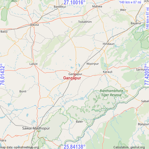
Gangāpur GPS coordinates[2]
26° 28' 20.964" North, 76° 43' 2.784" East
| Map corner | latitude | longitude |
|---|---|---|
| Upper-left | 27.10016°, | 76.01432° |
| Center: | 26.47249°, | 76.71744° |
| Lower-right: | 25.84138°, | 77.42057° |
| Map W x H: | 140×140 km | = 87×87mi |
| max Lat: | 34.9274° ⇑25.6% North |
| Gangāpur: | 26.47249° |
| min Lat: | ⇓74.4% South 8.09008° |
| min Long | Gangāpur | max Long |
| 68.82655° | 76.71744° | 96.81° |
| W 33.8%⇐ | ⇒66.2% E |
Elevation
Elevation of Gangāpur is 262 m = 860 ft, and this is 33.6 m = 110 ft below average elevation for this country.
| Max E: |
3681 m = 12077 ft | 38.5% |
| Avg. | 295.6 m = 970 ft | |
| Gangāpur | 262 m = 860 ft | |
Min E: |
1 m = 3 ft | 61.5% |
See also: Gangāpur elevation on elevation.city.
Geographical zone
Gangāpur is located in North temperate zone (between Tropic of Cancer and the Arctic Circle). Distance of this Northern Tropic circle is 337.5 km =209.7 mi to South.| Distance of | km | miles | from Gangāpur |
|---|---|---|---|
| North Pole | 7063.6 | 4389.1 | to North |
| Arctic Circle | 4457.7 | 2769.9 | to North |
| Tropic Cancer | 337.5 | 209.7 | to South |
| Equator | 2943.5 | 1829 | to South |


Nearby cities:
15 places around Gangāpur: (largest is in red/bold)
• Abhaneri
60.5 km =37.6 mi,  349°
349°
• Basi
77.5 km =48.2 mi,  300°
300°
• Baswa
76.4 km =47.5 mi, 349°
• Bayāna
74.7 km =46.4 mi,  49°
49°
• Bhasāwar
71 km =44.1 mi,  27°
27°
• Bāndīkūi
65.9 km =40.9 mi, 347°
• Dausa
59.9 km =37.2 mi,  320°
320°
• Hindaun
42.9 km =26.7 mi, 47°
• Karauli
31 km =19.3 mi,  84°
84°
• Lālsot
39.8 km =24.7 mi,  284°
284°
• Mahwah
67.2 km =41.8 mi,  18°
18°
• Sabalgarh
73.1 km =45.4 mi,  109°
109°
• Sawāi Mādhopur
62.3 km =38.7 mi,  216°
216°
• Todabhim
50.4 km =31.3 mi,  11°
11°
• Wer
75.9 km =47.2 mi,  36°
36°
Sources, notices
• [Note1] Compared only with cities in India existing in our database
• [Src1] Map data: © OpenStreetMap contributors (CC-BY-SA)
• [Src2] Other city data from geonames.org with taken over terms of usage.
• [Src3] Geographical zone / Annual Mean Temperature by Robert A. Rohde @ Wikipedia
