Narwar geodata
Narwar (Madhya Pradesh) is a populated place; located in India in Asia/Kolkata (GMT+5.5) time zone. With population of 16,948 people, there are 2289 cities with bigger population in this country. Compared to other cities in India, 68% of cities are located further ↓South; 52.2% of cities are located further →East and 65% of cities have lower elevation than Narwar. Note1


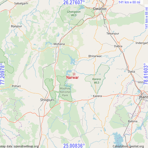
Narwar GPS coordinates[2]
25° 38' 38.04" North, 77° 54' 46.44" East
| Map corner | latitude | longitude |
|---|---|---|
| Upper-left | 26.27607°, | 77.20978° |
| Center: | 25.6439°, | 77.9129° |
| Lower-right: | 25.00836°, | 78.61603° |
| Map W x H: | 141×141 km | = 87.6×87.6mi |
| max Lat: | 34.9274° ⇑32% North |
| Narwar: | 25.6439° |
| min Lat: | ⇓68% South 8.09008° |
| min Long | Narwar | max Long |
| 68.82655° | 77.9129° | 96.81° |
| W 47.8%⇐ | ⇒52.2% E |
Elevation
Elevation of Narwar is 286 m = 938 ft, and this is 9.6 m = 31 ft below average elevation for this country.
| Max E: |
3681 m = 12077 ft | 35% |
| Avg. | 295.6 m = 970 ft | |
| Narwar | 286 m = 938 ft | |
Min E: |
1 m = 3 ft | 65% |
See also: India elevation on elevation.city.
Geographical zone
Narwar is located in North temperate zone (between Tropic of Cancer and the Arctic Circle). Distance of this Northern Tropic circle is 245.4 km =152.5 mi to South.| Distance of | km | miles | from Narwar |
|---|---|---|---|
| North Pole | 7155.7 | 4446.3 | to North |
| Arctic Circle | 4549.8 | 2827.1 | to North |
| Tropic Cancer | 245.4 | 152.5 | to South |
| Equator | 2851.3 | 1771.7 | to South |


Nearby cities:
15 places around Narwar: (largest is in red/bold)
• Antri
54.8 km =34.1 mi,  32°
32°
• Babīna
71.8 km =44.6 mi,  128°
128°
• Bhitarwār
25.8 km =16 mi,  50°
50°
• Dabra
49.9 km =31 mi,  57°
57°
• Datia
54.8 km =34.1 mi,  86°
86°
• Gwalior
70.2 km =43.6 mi,  21°
21°
• Jhānsi
70 km =43.5 mi,  107°
107°
• Jora
78.3 km =48.7 mi,  352°
352°
• Kailāras
79.3 km =49.3 mi,  338°
338°
• Karera
30.4 km =18.9 mi, 132°
• Khailār
70.6 km =43.9 mi,  118°
118°
• Kolāras
56.1 km =34.9 mi,  212°
212°
• Morār
71.9 km =44.7 mi, 25°
• Shivpuri
35.1 km =21.8 mi,  225°
225°
• Tekanpur
53.8 km =33.4 mi,  43°
43°
Sources, notices
• [Note1] Compared only with cities in India existing in our database
• [Src1] Map data: © OpenStreetMap contributors (CC-BY-SA)
• [Src2] Other city data from geonames.org with taken over terms of usage.
• [Src3] Geographical zone / Annual Mean Temperature by Robert A. Rohde @ Wikipedia
