Ilkal geodata
Ilkal (Karnataka) is a populated place; located in India in Asia/Kolkata (GMT+5.5) time zone. With population of 56,937 people, there are 778 cities with bigger population in this country. Compared to other cities in India, 78.1% of cities are located further ↑North; 72.5% of cities are located further →East and 86.2% of cities have lower elevation than Ilkal. Note1


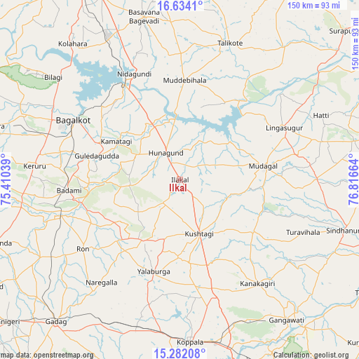
Ilkal GPS coordinates[2]
15° 57' 33.228" North, 76° 6' 48.636" East
| Map corner | latitude | longitude |
|---|---|---|
| Upper-left | 16.6341°, | 75.41039° |
| Center: | 15.95923°, | 76.11351° |
| Lower-right: | 15.28208°, | 76.81664° |
| Map W x H: | 150.3×150.3 km | = 93.4×93.4mi |
| max Lat: | 34.9274° ⇑78.1% North |
| Ilkal: | 15.95923° |
| min Lat: | ⇓21.9% South 8.09008° |
| min Long | Ilkal | max Long |
| 68.82655° | 76.11351° | 96.81° |
| W 27.5%⇐ | ⇒72.5% E |
Elevation
Elevation of Ilkal is 564 m = 1850 ft, and this is 268.4 m = 881 ft above average elevation for this country.
| Max E: |
3681 m = 12077 ft | 13.8% |
| Ilkal | 564 m 1850 ft | |
| Avg. | 295.6 m = 970 ft | |
Min E: |
1 m = 3 ft | 86.2% |
See also: Ilkal elevation on elevation.city.
Geographical zone
Ilkal is located in North Torrid zone (between Equator and Tropic of Cancer). Distance of this Northern Tropic circle is 831.4 km =516.6 mi to North.| Distance of | km | miles | from Ilkal |
|---|---|---|---|
| North Pole | 8232.6 | 5115.5 | to North |
| Arctic Circle | 5626.7 | 3496.3 | to North |
| Tropic Cancer | 831.4 | 516.6 | to North |
| Equator | 1774.5 | 1102.6 | to South |


Nearby cities:
15 places around Ilkal: (largest is in red/bold)
• Bagalkot
51.3 km =31.9 mi,  299°
299°
• Bilgi
68.3 km =42.4 mi,  309°
309°
• Bādāmi
46.9 km =29.1 mi,  263°
263°
• Gajendragarh
29.2 km =18.1 mi,  211°
211°
• Guledagudda
36 km =22.4 mi,  286°
286°
• Hungund
12.9 km =8 mi,  332°
332°
• Kerūr
60.9 km =37.8 mi,  275°
275°
• Kushtagi
24 km =14.9 mi,  159°
159°
• Lingsugūr
48.9 km =30.4 mi,  63°
63°
• Muddebihāl
42.1 km =26.2 mi,  2°
2°
• Mudgal
35.6 km =22.1 mi,  80°
80°
• Naregal
54 km =33.6 mi,  217°
217°
• Ron
49.8 km =30.9 mi,  234°
234°
• Tālīkota
60.9 km =37.8 mi,  20°
20°
• Yelbarga
39.7 km =24.7 mi,  195°
195°
Sources, notices
• [Note1] Compared only with cities in India existing in our database
• [Src1] Map data: © OpenStreetMap contributors (CC-BY-SA)
• [Src2] Other city data from geonames.org with taken over terms of usage.
• [Src3] Geographical zone / Annual Mean Temperature by Robert A. Rohde @ Wikipedia
